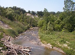
Rouge River, Ontario
| Rouge River (Katabokokonk) | |
| River | |
|
Rouge River at Kirkhams Road, Toronto
|
|
| Country | Canada |
|---|---|
| Province | Ontario |
| Region | Greater Toronto Area |
| Municipalities | Toronto, Pickering, Markham, Richmond Hill |
| Part of | Great Lakes Basin |
| Tributaries | |
| - left | Little Rouge River |
| - right | Little Rouge Creek, Katabokokonk Creek, Bruce Creek, Beaver Creek |
| Source | |
| - location | Richmond Hill |
| - elevation | 286 m (938 ft) |
| - coordinates | 43°56′07″N 79°24′34″W / 43.93528°N 79.40944°W |
| Mouth | Lake Ontario |
| - location | West Rouge, Toronto |
| - elevation | 74 m (243 ft) |
| - coordinates | 43°47′41″N 79°06′55″W / 43.79472°N 79.11528°WCoordinates: 43°47′41″N 79°06′55″W / 43.79472°N 79.11528°W |
| Basin | 336 km2 (130 sq mi) |
| Discharge | |
| - average | 1.76 m3/s (62 cu ft/s) |
| - max | 5.98 m3/s (211 cu ft/s) |
| - min | 0.45 m3/s (16 cu ft/s) |
The Rouge River is a river in Markham, Pickering, Richmond Hill and Toronto in the Greater Toronto Area of Ontario, Canada. The river flows from the Oak Ridges Moraine to Lake Ontario at the eastern border of Toronto, and is the location of Rouge Park, the only national park in Canada within a municipality. At its southern end, the Rouge River is the boundary between Toronto and southwestern Pickering in the Regional Municipality of Durham.
The Rouge River begins in the Oak Ridges Moraine in Richmond Hill and flows past: Markham, northwest, central, to south, including a couple of conservation areas, the eastern edge of Scarborough and Rouge Valley Park.
The watershed of the Rouge River is located in the municipalities of Richmond Hill and Markham in the Regional Municipality of York; Pickering in the Regional Municipality of Durham; and Toronto. Tributaries of the Rouge River also extend into the municipalities of Aurora and Whitchurch-Stouffville in the Regional Municipality of York. The total area of the watershed is 336 square kilometres (130 sq mi), of which 40% is agricultural land, 35% urban, 24% forest/wetland/meadow and 1% watercourses/waterbodies.
The headwaters of the Rouge River and its tributaries are found in the Oak Ridges Moraine. Water flows down from the elevated moraine to Lake Ontario. The Rouge River meets Lake Ontario at Rouge Beach. At Rouge Beach, the Rouge Marsh is to the north and Lake Ontario to the south. More than half the remaining wetlands in the Greater Toronto Area are located here in the southern Rouge River.
...
Wikipedia


