Rottumerplaat

Observation post at Rottumerplaat
|
|

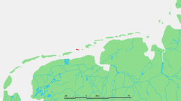
Location of Rottumerplaat in the Wadden Sea
|
|
| Geography | |
|---|---|
| Coordinates | 53°32′30″N 6°28′51″E / 53.54167°N 6.48083°ECoordinates: 53°32′30″N 6°28′51″E / 53.54167°N 6.48083°E |
| Archipelago | (West) Frisian Islands |
| Adjacent bodies of water | North Sea, Wadden Sea |
| Administration | |
|
Netherlands
|
|
| Province | Groningen |
| Municipality | Eemsmond |
| Demographics | |
| Population | Uninhabited |
Rottumerplaat (Dutch pronunciation: [ˌrɔtɵmərˈplaːt]) is one of the three islands that make up Rottum in the West Frisian Islands. The island is located in the North Sea off the Dutch coast. It is situated between the islands of Schiermonnikoog and Rottumeroog.
Access to the island is prohibited since Rottumerplaat is a resting and forage area for numerous bird species. Rijkswaterstaat, Staatsbosbeheer and the Ministry of Agriculture, Nature and Food Quality are responsible for the administration of the island. Twice a year marine debris is cleaned from the island.
Sediment deposition has caused the island to become significantly larger in recent years.
Rottumerplaat is the northernmost point of the Netherlands.
Rottumerplaat is a resting and forage area for sanderling, dunlin and Kentish plovers. Common eider, common shelduck, Arctic tern, common tern, little tern, Kentish plover, and ringed plover nest on the island. From 1996 the Sandwich tern nested on Rottumerplaat, but has since stopped doing so.
...
Wikipedia
