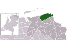
Eemsmond
| Eemsmond | |||
|---|---|---|---|
| Municipality | |||
|
|||
 Location in Groningen |
|||
| Coordinates: 53°24′N 6°40′E / 53.400°N 6.667°ECoordinates: 53°24′N 6°40′E / 53.400°N 6.667°E | |||
| Country | Netherlands | ||
| Province | Groningen | ||
| Established | 1 January 1979 | ||
| Government | |||
| • Body | Municipal council | ||
| • Mayor | Marijke van Beek (PvdA) | ||
| Area | |||
| • Total | 543.35 km2 (209.79 sq mi) | ||
| • Land | 189.81 km2 (73.29 sq mi) | ||
| • Water | 353.54 km2 (136.50 sq mi) | ||
| Elevation | 2 m (7 ft) | ||
| Population (May 2014) | |||
| • Total | 15,864 | ||
| • Density | 84/km2 (220/sq mi) | ||
| Postcode | 9979–9989, 9995–9999 | ||
| Area code | 0595, 0596 | ||
| Website | www |
||
Eemsmond (Dutch pronunciation: [ˈeːmsmɔnt]; English: Ems Mouth) is a municipality with a population of 15,864 in the north of the province of Groningen in the northeast of the Netherlands.
The municipality of Hefshuizen was established on 1 January 1979 by merging the municipalities of Uithuizen and Uithuizermeeden. On 1 January 1990, the municipalities of Kantens, Usquert, and Warffum were added. On 1 January 1992, the name of the municipality was changed from Hefshuizen to Eemsmond, which means Ems Mouth.
Eemsmond is located at 53°24′N 6°40′E / 53.400°N 6.667°E in the north of the province of Groningen and in the northeast of the Netherlands.
The population centers in the municipality are: Eemshaven, Eppenhuizen, Kantens, Oldenzijl, Oosteinde, Oosternieland, Oudeschip, Roodeschool, Rottum, Startenhuizen, Stitswerd, Uithuizen, Uithuizermeeden, Usquert, Warffum, and Zandeweer.
...
Wikipedia


