Rosenhayn, New Jersey
| Rosenhayn, New Jersey | |
|---|---|
| Census-designated place | |
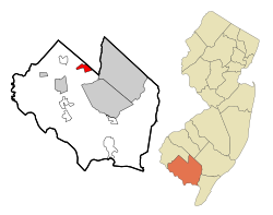
 Map of Rosenhayn highlighted within Cumberland County. Right: Location of Cumberland County in New Jersey. |
|
| Coordinates: 39°28′43″N 75°08′16″W / 39.47868°N 75.13791°WCoordinates: 39°28′43″N 75°08′16″W / 39.47868°N 75.13791°W | |
| Country |
|
| State |
|
| County | Cumberland |
| Township | Deerfield |
| Area | |
| • Total | 2.654 sq mi (6.874 km2) |
| • Land | 2.654 sq mi (6.874 km2) |
| • Water | 0.000 sq mi (0.000 km2) 0.00% |
| Elevation | 108 ft (33 m) |
| Population (2010 Census) | |
| • Total | 1,098 |
| • Density | 413.7/sq mi (159.7/km2) |
| Time zone | Eastern (EST) (UTC-5) |
| • Summer (DST) | EDT (UTC-4) |
| ZIP code | 08352 |
| Area code(s) | 856 |
| FIPS code | 3464740 |
| GNIS feature ID | 02389778 |
Rosenhayn is an unincorporated community and census-designated place (CDP) located within Deerfield Township, in Cumberland County, New Jersey, United States. It is part of the Vineland-Milleville- Bridgeton Primary Metropolitan Statistical Area for statistical purposes. As of the 2010 United States Census, the CDP's population was 1,098.
Rosenhayn was founded as a Jewish agricultural colony and the 1898 Rosenhayn synagogue is one of the fewer than 100 surviving nineteenth century synagogue buildings in the United States.
According to the United States Census Bureau, the CDP had a total area of 2.654 square miles (6.874 km2), all land.
The 2010 United States Census counted 1,098 people, 382 households, and 273.9 families residing in the CDP. The population density was 413.7 per square mile (159.7/km2). The CDP contained 404 housing units at an average density of 152.2 per square mile (58.8/km2). The racial makeup of the CDP was 64.21% (705) White, 18.03% (198) Black or African American, 1.28% (14) Native American, 1.46% (16) Asian, 0.00% (0) Pacific Islander, 9.29% (102) from other races, and 5.74% (63) from two or more races. Hispanics or Latinos of any race were 17.58% (193) of the population.
...
Wikipedia
