Rosemount, MN
| Rosemount | |
|---|---|
| City | |
| Rosemount, Minnesota | |
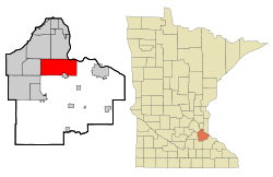
 Location of the city of Rosemount within Dakota County, Minnesota |
|
| Coordinates: 44°44′28″N 93°7′11″W / 44.74111°N 93.11972°W | |
| Country | United States |
| State | Minnesota |
| County | Dakota |
| Government | |
| • Mayor | Bill Droste |
| Area | |
| • Total | 35.21 sq mi (91.19 km2) |
| • Land | 33.22 sq mi (86.04 km2) |
| • Water | 1.99 sq mi (5.15 km2) |
| Elevation | 965 ft (294 m) |
| Population (2010) | |
| • Total | 21,874 |
| • Estimate (2015) | 23,413 |
| • Density | 658.5/sq mi (254.2/km2) |
| Time zone | Central (CST) (UTC-6) |
| • Summer (DST) | CDT (UTC-5) |
| ZIP code | 55068 |
| Area code(s) | 651 |
| FIPS code | 27-55726 |
| GNIS feature ID | 0650291 |
| Website | City of Rosemount |
Rosemount is a city in Dakota County, Minnesota, United States, in the Twin Cities Metropolitan Area. The population was 21,874 at the 2010 census. Rosemount was established as a township in 1858 and incorporated as a city in 1972, encompassing the old village of Rosemount and Pine Bend. According to the city's website, there was some debate over whether to name the township Saratoga or Rosemount, with the latter finally being chosen to reflect the town's Irish heritage, and to remain in keeping with the name given to the post office a few years earlier. Rosemount is home to the Pine Bend Refinery, which is the largest oil refinery in Minnesota and the 14th-largest in the United States. Rosemount was also home to a military gunpowder plant in the 1940s called Gopher Ordnance Works.
According to the United States Census Bureau, the city has a total area of 35.21 square miles (91.19 km2), of which 33.22 square miles (86.04 km2) is land and 1.99 square miles (5.15 km2) is water.
U.S. Highway 52, Minnesota Highway 3, Minnesota Highway 55, and County Road 42 are four of the main routes in Rosemount.
Rosemount is the home of the Rosemount High School "Irish" and Dakota County Technical College, a member of the Minnesota State Colleges and Universities system.
...
Wikipedia
