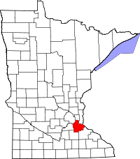
Dakota County, Minnesota
| Dakota County, Minnesota | |
|---|---|

Dakota County Courthouse
|
|
 Location in the U.S. state of Minnesota |
|
 Minnesota's location in the U.S. |
|
| Founded | October 27, 1849 |
| Named for | Dakota people |
| Seat | Hastings |
| Largest city | Eagan |
| Area | |
| • Total | 587 sq mi (1,520 km2) |
| • Land | 562 sq mi (1,456 km2) |
| • Water | 25 sq mi (65 km2), 4.2% |
| Population (est.) | |
| • (2015) | 428,638 |
| • Density | 709/sq mi (274/km²) |
| Congressional district | 2nd |
| Time zone | Central: UTC-6/-5 |
| Website | www |
Dakota County is the third-most populous county in the U.S. state of Minnesota. As of the 2010 census, the population was 398,552. The county seat is Hastings. Dakota County is named after the Dakota Sioux tribal bands who settled in the area. The name is recorded as "Dahkotah" in the United States Census records until 1851.
Dakota County is included in the Minneapolis–St. Paul–Bloomington, MN–WI Metropolitan Statistical Area, the sixteenth largest metropolitan area in the United States with about 3.3 million residents. The county is bordered by the Minnesota and Mississippi Rivers on the north, and the state of Wisconsin on the east.
The county was the site of historical events at Mendota that defined the state's future, including providing materials for the construction of Fort Snelling across the river and the signing of the Treaty of Traverse des Sioux which ceded land from the native Dakota nation for the Minnesota Territory. The county's history was initially tied to the confluence of the Mississippi and Minnesota Rivers, both strategically important for United States expansion and as the convergence of the Dakota and Ojibwe nations who regarded the site as sacred. Influence shifted westward during the post-World War II settlement boom when Interstate 35 connected the western half of the county to Minneapolis and Saint Paul and bedroom communities grew. Most work outside the county but like many metro counties, Dakota continues to absorb industry and jobs from the core cities.
...
Wikipedia
