Rose Point, Pennsylvania
| Rose Point, Pennsylvania | |
|---|---|
| Unincorporated community | |

The actual Rose Point at the center of the community
|
|
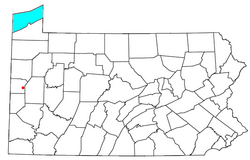
 Location of Rose Point, Pennsylvania |
|
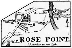
 Map of Rose Point in 1872 |
|
| Coordinates: 40°58′12″N 80°11′11″W / 40.97000°N 80.18639°WCoordinates: 40°58′12″N 80°11′11″W / 40.97000°N 80.18639°W | |
| Country | United States |
| State | Pennsylvania |
| County | Lawrence |
| Township | Slippery Rock |
| Elevation | 1,106 ft (337 m) |
| Time zone | Eastern (EST) (UTC-5) |
| • Summer (DST) | EDT (UTC-4) |
| GNIS feature ID | 1185451 |
Rose Point is an unincorporated community in east central Slippery Rock Township, Lawrence County, Pennsylvania, United States, very close to the Butler County line. Founded approximately 200 years ago, the community lies in a rural yet formerly industrial region of fields and broken terrain.
Rose Point's elevation is 1,106 feet (337 m). It lies on the northern side of U.S. Route 422 at its intersection with Rose Point Road, along the gorge of the Slippery Rock Creek. Located east of the city of New Castle, the county seat of Lawrence County, the community sits approximately midway between New Castle and Butler. It lies near two of U.S. 422's significant intersections: with U.S. Route 19, about 1 mile (1.6 km) away, and with Interstate 79, about 3 miles (5 km) away. In the vicinity of Rose Point are multiple state parks: Moraine State Park, including the large Lake Arthur, is located to the east not far past Interstate 79, while McConnells Mill State Park sits on the opposite side of U.S. 422.
The bedrock around Rose Point is primarily the soft rock of the large Vanport Limestone layer, which has a 93.6% content of calcium carbonate and low levels of magnesium carbonate and silica. Hydrocarbons were originally prevalent in the township: significant coal beds of fine quality were found throughout the area, and oil wells were drilled in hopes of reaching the edge of the Venango County-centered oil fields. Seen most clearly in the deep and broken gorge of the Slippery Rock Creek is the karst topography of the region around Rose Point, which also includes significant cave complexes. Leading among the caves in the area is the Harlansburg Cave, Pennsylvania's longest cave, which has been reported to extend from Harlansburg (eleven miles away) to Rose Point. Smaller caves such as the Rose Point Cave also exist in the area, parallel to the Harlansburg Cave; all these caves are believed to have been formed by stream water forced underground during wetter times of the year, causing their passages to be maze-like rather than linear.
...
Wikipedia
