Slippery Rock Township, Lawrence County, Pennsylvania
| Slippery Rock Township | |
|---|---|
| Township | |

|
|
 Location of Slippery Rock Township in Lawrence County |
|
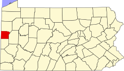
 Location of Lawrence County in Pennsylvania |
|
| Country | United States |
| State | Pennsylvania |
| County | Lawrence County |
| Established | 1813 |
| Area | |
| • Total | 30.2 sq mi (78 km2) |
| • Land | 30.1 sq mi (78 km2) |
| • Water | 0.1 sq mi (0.3 km2) |
| Population (2010) | |
| • Total | 3,283 |
| • Density | 110/sq mi (42/km2) |
| Time zone | EST (UTC-4) |
| • Summer (DST) | EDT (UTC-5) |
| Area code(s) | 724 |
Slippery Rock Township is a township in Lawrence County, Pennsylvania, United States. The population was 3,283 at the 2010 census.
The township was linked to New Castle, Ellwood City and Pittsburgh in 1908 by the Pittsburgh, Harmony, Butler and New Castle Railway, an interurban trolley line. The line closed on 15 June 1931, and the trolleys were replaced by buses.
McConnell's Mill Covered Bridge was listed on the National Register of Historic Places in 1980.
According to the United States Census Bureau, the township has a total area of 30.2 square miles (78.2 km2), of which 30.1 square miles (78.0 km2) is land and 0.1 square miles (0.3 km2), or 0.26%, is water.
Located within Slippery Rock Township is McConnells Mill State Park along the Slippery Rock Creek Gorge.
As of the census of 2000, there were 3,179 people, 1,203 households, and 916 families residing in the township. The population density was 105.5 people per square mile (40.7/km²). There were 1,285 housing units at an average density of 42.7/sq mi (16.5/km²). The racial makeup of the township was 99.18% White, 0.06% African American, 0.19% Native American, 0.13% Asian, 0.13% from other races, and 0.31% from two or more races. Hispanic or Latino of any race were 0.38% of the population.
...
Wikipedia
