Rose Hill, Fairfax County, Virginia
| Rose Hill, Fairfax County, Virginia | |
|---|---|
| Census-designated place | |

Rose Hill Shopping Center, August 2015
|
|
 Location within Fairfax county |
|
| Location within Fairfax county | |
| Coordinates: 38°47′21″N 77°6′32″W / 38.78917°N 77.10889°WCoordinates: 38°47′21″N 77°6′32″W / 38.78917°N 77.10889°W | |
| Country | United States |
| State | Virginia |
| County | Fairfax |
| Area | |
| • Total | 5.57 sq mi (14.43 km2) |
| • Land | 5.56 sq mi (14.39 km2) |
| • Water | 0.02 sq mi (0.04 km2) |
| Elevation | 203 ft (62 m) |
| Population (2010) | |
| • Total | 20,226 |
| • Density | 3,640/sq mi (1,405.6/km2) |
| Time zone | Eastern (EST) (UTC-5) |
| • Summer (DST) | EDT (UTC-4) |
| FIPS code | 51-68880 |
| GNIS feature ID | 2389774 |
Rose Hill is a census-designated place (CDP) in Fairfax County, Virginia, United States. The population was 20,226 at the 2010 census. Built in the mid-1950s, Rose Hill is the largest of the subdivisions that make up the CDP, which is just southwest of Alexandria; others include Wilton Woods, Burgundy Village, and Winslow Heights. Street addresses are in Alexandria ZIP codes 22310, 22303 and 22315.
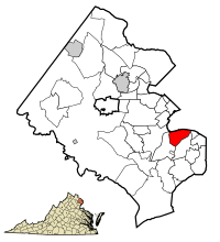
Rose Hill is located in southeastern Fairfax County at 38°47′21″N 77°6′32″W / 38.78917°N 77.10889°W (38.789263, -77.108971). It is bordered to the north by the city of Alexandria, to the east by Huntington, to the south by Groveton and Hayfield, to the southwest by Kingstowne, and to the west by Franconia. The CDP's borders follow the Capital Beltway and CSX rail line on the north, South Van Dorn Street and some smaller roads on the west, South Kings Highway on the south, and Shaffer Drive and Telegraph Road on the east.
According to the United States Census Bureau, the Rose Hill CDP has a total area of 5.57 square miles (14.43 km2), of which 0.02 square miles (0.04 km2), or 0.28%, is water.
...
Wikipedia


