Rondebosch, Cape Town
| Rondebosch | |
|---|---|

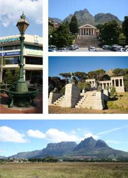
Top left: Victorian era cast iron Fountain at the historic centre of Rondebosch. Top right: University of Cape Town upper campus. Centre right: Rhodes Memorial. Bottom: Rondebosch Common
|
|
 Street map of Rondebosch |
|
|
|
|
| Coordinates: 33°57′48″S 18°28′35″E / 33.96333°S 18.47639°ECoordinates: 33°57′48″S 18°28′35″E / 33.96333°S 18.47639°E | |
| Country | South Africa |
| Province | Western Cape |
| Municipality | City of Cape Town |
| Area | |
| • Total | 6.42 km2 (2.48 sq mi) |
| Population (2011) | |
| • Total | 14,591 |
| • Density | 2,300/km2 (5,900/sq mi) |
| Racial makeup (2011) | |
| • Black African | 16.5% |
| • Coloured | 9.6% |
| • Indian/Asian | 6.1% |
| • White | 62.7% |
| • Other | 5.0% |
| First languages (2011) | |
| • English | 84.3% |
| • Afrikaans | 7.6% |
| • Xhosa | 1.8% |
| • Other | 6.3% |
| Postal code (street) | 7700 |
| PO box | 7701 |
| Area code | (021) 685/686 |
Rondebosch is one of the Southern Suburbs of Cape Town, South Africa. It is primarily a residential suburb, with a medium-size shopping area, a small business district as well as the main campus of the University of Cape Town.
Four years after the first Dutch settlement at the Cape in 1652, the first experimental crops were grown along the banks of the Liesbeek River (at that stage called the Amstel or Versse Rivier). On the banks of the river, a circular grove of thorn trees, or Ronde Doorn Bosje, was turned into a kraal. In 1657, the first group of Dutch East India Company employees gained "free burgher" (free citizen) status and were granted land along the river in the area now known as Rondebosch.
In the 19th and 20th centuries, Rondebosch became a predominantly English-speaking area and was declared a whites-only area under the Group Areas Act. Since the end of Apartheid in the mid-1990s, the area has become increasingly integrated.
Rondebosch lies between the slopes of Devil's Peak in the west and the M5 freeway in the east; it is one of the Southern Suburbs of Cape Town, which lie along the eastern slope of the Table Mountain massif. The suburb's western border with the Table Mountain National Park is defined by the M3 freeway. To the north are the suburbs of Rosebank and Mowbray, while to the south are Newlands and Claremont. The eastern border of Rondebosch is the M5 freeway; beyond the freeway are Sybrand Park, Athlone and Rondebosch East.
...
Wikipedia


