Athlone, Cape Town
| Athlone | |
|---|---|

Athlone, just after the demolition of the Cooling Towers
|
|
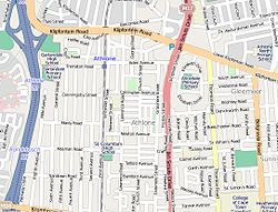
 Street map of Athlone |
|
|
|
|
| Coordinates: 33°57′40″S 18°30′11″E / 33.96111°S 18.50306°ECoordinates: 33°57′40″S 18°30′11″E / 33.96111°S 18.50306°E | |
| Country | South Africa |
| Province | Western Cape |
| Municipality | City of Cape Town |
| Government | |
| • Councillor | Mustapha Murudker (Ward 48) ANC Patrick Hill (Ward 60) (DA) |
| Area | |
| • Total | 1.50 km2 (0.58 sq mi) |
| Population (2011) | |
| • Total | 8,893 |
| • Density | 5,900/km2 (15,000/sq mi) |
| Racial makeup (2011) | |
| • Black African | 8.5% |
| • Coloured | 82.8% |
| • Indian/Asian | 4.1% |
| • White | 1.1% |
| • Other | 3.5% |
| First languages (2011) | |
| • English | 81.6% |
| • Afrikaans | 11.7% |
| • Other | 6.7% |
| Postal code (street) | 7764 |
| PO box | 7760 |
Athlone is a suburb of Cape Town located to the east of the city centre on the Cape Flats, south of the N2 highway. It is named after Alexander Cambridge, 1st Earl of Athlone who was Governor-General of the Union of South Africa from 1924 to 1930. Two of the suburb's main landmarks are Athlone Stadium and the decommissioned coal burning Athlone Power Station. Athlone is mainly residential and is served by a railway station of the same name. It however includes industrial (Athlone Industria 1 & 2) and commercial zones (Athlone CBD and Gatesville). There are many "sub-areas" within Athlone, including Manenberg, Gatesville, Rylands, Belgravia Estate, Bridgetown, Crawford and Hazendal.
Athlone is also the home of the Trojan Horse Memorial, a reminder of the Trojan Horse Incident which took place in 1985, when three anti-apartheid protesters were killed and fifteen others wounded in a police ambush. The incident took place near the Alexander Sinton Secondary School where students had demanded to attend school the month before.
Athlone is also the home of the Robert Waterwitch / Colleen Williams Memorial, established in memory of two ANC activists who died in the struggle against apartheid.
As of the census of 2001, there were 11,556 households and 45,056 people residing in the suburb. The racial makeup of the suburb was 3.21% Black African, 69.66% Coloured, 23.45% Indian/Asian, 3.68% White and 0% from other races.
...
Wikipedia


