Mowbray, Cape Town
| Mowbray | |
|---|---|

Mostert's Mill, February 2008
|
|
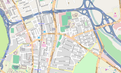
 Street map of Mowbray |
|
|
|
|
| Coordinates: 33°56′46″S 18°28′34″E / 33.94611°S 18.47611°ECoordinates: 33°56′46″S 18°28′34″E / 33.94611°S 18.47611°E | |
| Country | South Africa |
| Province | Western Cape |
| Municipality | City of Cape Town |
| Area | |
| • Total | 2.76 km2 (1.07 sq mi) |
| Population (2011) | |
| • Total | 4,726 |
| • Density | 1,700/km2 (4,400/sq mi) |
| Racial makeup (2011) | |
| • Black African | 44.2% |
| • Coloured | 11.3% |
| • Indian/Asian | 4.0% |
| • White | 36.1% |
| • Other | 4.3% |
| First languages (2011) | |
| • English | 68.0% |
| • Afrikaans | 8.0% |
| • Xhosa | 7.4% |
| • Zulu | 2.1% |
| • Other | 14.5% |
| Postal code (street) | 7700 |
| PO box | 7705 |
Mowbray is one of the Southern Suburbs of Cape Town, South Africa and lies on the slopes of Devil's Peak. Mowbray is at a junction of several major Cape Town highways and has an important multi-modal public transport interchange at Mowbray railway station. Its original name was Driekoppen ("Three heads" in Dutch).
Mowbray is bounded on the west by the M3 freeway, beyond which lies Devil's Peak, and on the north by the N2 freeway, beyond which lies the suburb of Observatory. Towards the east, the built-up area of Mowbray ends at the M5 freeway, beyond which lies the Black River and the suburb of Pinelands; however, the official boundaries of Mowbray also include the Rondebosch and Mowbray golf courses, which lie beyond the M5, towards Sybrand Park and Pinelands respectively. On the south, Mowbray borders on the suburb of Rosebank with a less well-defined boundary.
The Liesbeeck River flows from south to north through Mowbray, and separates the suburb into two distinct sections. The western section lies on the lower slopes of Devil's Peak, and contains most of the commercial development in the suburb. The eastern section, known as "Little Mowbray", lies on the low hill between the Liesbeeck and Black Rivers.
The well-known Quaker Peace Centre has its offices in Mowbray.
Mowbray is well-connected to the road network, being bounded (as described above) by the M3, M5 and N2 freeways. Apart from the freeways, the main roads in the suburb are Main Road (M4) and Liesbeeck Parkway (M57), which run north-south; Victoria Road/St. Peter's Road/Durban Road/Klipfontein Road (M18) which runs west-east; and Raapenberg Road (M52) which runs to the north-east towards Pinelands.
...
Wikipedia


