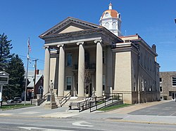
Romney, West Virginia
| Romney, West Virginia | |
|---|---|
| City | |
| City of Romney | |
 |
|
| Nickname(s): West Virginia's Oldest Town | |
 Location of Romney in West Virginia |
|
| Coordinates: 39°20′42″N 78°45′25″W / 39.34500°N 78.75694°WCoordinates: 39°20′42″N 78°45′25″W / 39.34500°N 78.75694°W | |
| Country | United States |
| State | West Virginia |
| County | Hampshire |
| Government | |
| • Mayor | Daniel O. Hileman |
| Area | |
| • Total | 0.96 sq mi (2.49 km2) |
| • Land | 0.96 sq mi (2.49 km2) |
| • Water | 0 sq mi (0 km2) |
| Elevation | 820 ft (820 m) |
| Population (2010) | |
| • Total | 1,848 |
| • Estimate (2013) | 1,796 |
| • Density | 1,925.0/sq mi (743.2/km2) |
| Time zone | EST (UTC-5) |
| • Summer (DST) | EDT (UTC-4) |
| ZIP code | 26757 |
| Area code(s) | 304 |
| FIPS code | 54-70084 |
| GNIS feature ID | 1560582 |
| Website | City of Romney |
Romney is a city in and the county seat of Hampshire County, West Virginia, USA. The population was 1,940 at the 2000 census, while the area covered by the city's ZIP code had a population of 5,873. The population was 1,848 at the 2010 census. Originally settled in 1725 by hunters and traders, Romney was known as Pearsall's Flats and was the site of the French and Indian War stockade Fort Pearsall. Romney is the oldest town in West Virginia, chartered December 23, 1762. (This status is contested by Shepherdstown, which was chartered in the same year). Named for the Cinque Ports town of Romney, Kent, England by Thomas Fairfax, 6th Lord Fairfax of Cameron, the town still bears placenames and symbols from its colonial past such as its Marsham Street, named for Robert Marsham, 2nd Baron Romney. It is also home to the West Virginia Schools for the Deaf and Blind and the nation's First Confederate Memorial in Indian Mound Cemetery.
Romney is located at 39°20′42″N 78°45′25″W / 39.34500°N 78.75694°W (39.344915, -78.756960).
...
Wikipedia
