New Romney
| New Romney | |
|---|---|
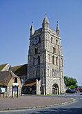
 New Romney Church tower |
|
| New Romney shown within Kent | |
| Population | 6,996 (2011) |
| OS grid reference | TR066249 |
| Civil parish |
|
| District | |
| Shire county | |
| Region | |
| Country | England |
| Sovereign state | United Kingdom |
| Post town | NEW ROMNEY |
| Postcode district | TN28 |
| Dialling code | 01797 |
| Police | Kent |
| Fire | Kent |
| Ambulance | South East Coast |
| EU Parliament | South East England |
| UK Parliament | |
New Romney is a small town in Kent, England, on the edge of Romney Marsh, an area of flat, rich agricultural land reclaimed from the sea after the harbour began to silt up. New Romney, one of the original Cinque Ports, was once a sea port, with the harbour adjacent to the church, but is now more than a mile from the sea. A mooring ring can still be seen in front of the church. It is the headquarters of the Romney, Hythe and Dymchurch Railway.
New Romney is not significantly different in age from the nearby village of Old Romney. However New Romney, now about a mile and a half from the seafront, was originally a harbour town at the mouth of the River Rother. The Rother estuary was always difficult to navigate, with many shallow channels and sandbanks. To make navigation easier two large rocks, one bigger than the other, were placed at the entrance to the main channel. The names of two local settlements, Greatstone and Littlestone, are a reminder of these aids. Another possible explanation for these place-names is a result of the effects of Longshore Drift, which disperses shingle and sand deposits, from west to east, with heavier stones accumulating in the area known as Greatstone, while far smaller shingle is to be found in great quantities at Littlestone. Very fine sand is found further east at neighbouring St Mary's Bay.
In the latter part of the thirteenth century a series of severe storms weakened the coastal defences of Romney Marsh, and the South England flood of February 1287 almost destroyed the town, as it did destroy the nearby ancient parish of Broomhill. The harbour and town were filled with sand, silt, mud and debris, and the River Rother changed course to run out into the sea near Rye, Sussex. The mud, silt and sand were never entirely removed from the town, which is why many old buildings, especially the church, have steps leading down into them from the present pavement level.
New Romney is one of the original Cinque Ports of England, although its importance declined rapidly during the fourteenth and fifteenth centuries after the loss of the harbour. Archaeological investigations in 2007 during replacement of the town's main drainage have cast new light on the medieval origins and development of the town.
...
Wikipedia

