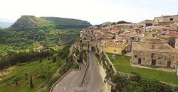
Rometta
| Rometta | |
|---|---|
| Comune | |
| Comune di Rometta | |

Skyline
|
|
| Location of Rometta in Italy | |
| Coordinates: 38°10′N 15°25′E / 38.167°N 15.417°ECoordinates: 38°10′N 15°25′E / 38.167°N 15.417°E | |
| Country | Italy |
| Region | Sicily |
| Province / Metropolitan city | Province of Messina (ME) |
| Frazioni | Rometta Marea, Gimello, Mazzabruno, Santa Domenica, Rapano, San Cono, Sotto Castello, S. Andrea |
| Area | |
| • Total | 32.5 km2 (12.5 sq mi) |
| Elevation | 560 m (1,840 ft) |
| Population (Dec. 2004) | |
| • Total | 6,458 |
| • Density | 200/km2 (510/sq mi) |
| Demonym(s) | Romettesi |
| Time zone | CET (UTC+1) |
| • Summer (DST) | CEST (UTC+2) |
| Postal code | 98043 |
| Dialing code | 090 |
| Patron saint | San Leone Vescovo |
| Saint day | 20 February |
| Website | Official website |
Rometta (Sicilian: Ramietta) is a comune (municipality) in the Province of Messina in the Italian region Sicily, located about 180 kilometres (110 mi) east of Palermo and about 12 kilometres (7 mi) west of Messina. As of 31 December 2004, it had a population of 6,458 and an area of 32.5 square kilometres (12.5 sq mi).
The municipality of Rometta contains the frazioni (subdivisions, mainly villages and hamlets) Rometta Marea, Gimello, Santa Domenica, Rapano, San Cono, Sotto Castello, and S. Andrea. Rometta borders the following municipalities: Messina, Monforte San Giorgio, Roccavaldina, Saponara, Venetico, Spadafora.
...
Wikipedia

