Rodoanel Mário Covas
| Rodoanel Mário Covas | |
|---|---|
| Via Perimetral Metropolitana (until 1990) Rodoanel Metropolitano de São Paulo (until 2001) |
|

Rodoanel Mário Covas and its four sections. The west (purple), south (green) and east (yellow) sections are already completed. The municipality of São Paulo is highlighted in white.
|
|

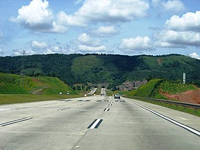
A view of the highway with the entrance to the first tunnels
|
|
| Route information | |
| Maintained by RodoAnel (CCR) - Dersa (in the West Segment since 2008) and SPMar (Bertin) (in the South and East Segments since 2011) | |
| Length: | 177 km (110 mi) 132.5 km (82.3 mi) completed until now. |
| Existed: |
|
| Restrictions: | The North Segment is still in construction (it will be completed in 2017). |
| Major junctions | |
| Beltway around São Paulo, Brazil | |
| West end: |
Av. Raimundo P. Magalhães Perus, São Paulo, SP |
|
|
|
| East end: |
Rodovia Presidente Dutra Arujá, SP |
| Highway system | |
|
Highways in Brazil |
|
Rodoanel Mário Covas (official designation SP-021) is the planned (and partially built) beltway of the Greater São Paulo, Brazil. Upon its completion, it will have a length of 177 km (110 mi), with a radius of approximately 23 km (14 mi) from the geographical center of the city. It was named after Mário Covas, who was mayor of the city of São Paulo (1983–1985) and a state governor (1994-1998/1998-2001) until his death from cancer. It is a controlled access highway with a speed limit of 100 km/h (62 mph) under normal weather and traffic circumstances.
The first section was inaugurated in October 2002, starting at the Estrada Velha de Campinas (lit. Old Road of Campinas), in the northern part of São Paulo, and ending at the Régis Bittencourt highway, in Embu, covering 32 km (20 mi). It crosses Anhangüera, Bandeirantes, Castelo Branco, and Raposo Tavares highways. There are urban accesses to the cities of Osasco and Carapicuíba, but it also crosses through the municipalities of Barueri, Santana de Parnaíba, Embu, Cotia, and São Paulo. The current segment has three tunnels, one of them being the largest and widest one in Brazil, with 1.6 km (0.99 mi), 62 viaducts and six bridges.
...
Wikipedia
