Santana de Parnaíba
| Santana de Parnaíba | |||
|---|---|---|---|
| Municipality | |||

Church in Santana de Parnaíba
|
|||
|
|||
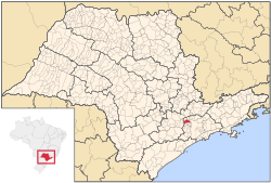
 Location in São Paulo state |
|||
| Location in Brazil | |||
| Coordinates: 23°26′38″S 46°55′4″W / 23.44389°S 46.91778°WCoordinates: 23°26′38″S 46°55′4″W / 23.44389°S 46.91778°W | |||
| Country |
|
||
| Region | Southeast Brazil | ||
| State | São Paulo | ||
| Metropolitan Region | São Paulo | ||
| Area | |||
| • Total | 179.95 km2 (69.48 sq mi) | ||
| Population (2015) | |||
| • Total | 126,574 | ||
| • Density | 700/km2 (1,800/sq mi) | ||
| Time zone | BRT (UTC-3) | ||
| • Summer (DST) | BRST (UTC-2) | ||
Santana de Parnaíba is a city and municipality in the state of São Paulo in Brazil. It is part of the Metropolitan Region of São Paulo. The population is 126,574 (2015 est.) in an area of 179.95 km². It was founded in 1625 near the Tietê River by Susana Dias, an important Bandeirante (Brazilian pioneers) wife.
The word Parnaíba means rocky river.
The municipality contains and administers the 367 hectares (910 acres) Tamboré Biological Reserve, a strictly protected conservation unit.
...
Wikipedia


