Rockfish Gap
| Rockfish Gap | |
|---|---|

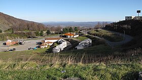
A cluster of mostly-defunct restaurant and lodging businesses resides at Rockfish Gap, near the junction of the Skyline Drive and the Blue Ridge Parkway.
|
|
| Elevation | 1,903 ft (580 m) |
| Traversed by |
|
| Location | Border of Augusta and Nelson counties, Virginia, United States |
| Range | Blue Ridge Mountains |
| Coordinates | 38°01′57″N 78°51′29″W / 38.0324°N 78.8580°WCoordinates: 38°01′57″N 78°51′29″W / 38.0324°N 78.8580°W |
Rockfish Gap is a wind gap located in the Blue Ridge Mountains between Charlottesville and Waynesboro, Virginia, United States, through Afton Mountain, which is frequently used to refer to the gap.
Joining the Shenandoah Valley to the Piedmont region of the state, it is the site of the mountain crossing of Interstate 64, U.S. Route 250, and the former Blue Ridge Railroad which later became part of the Chesapeake and Ohio Railway and is currently part of the CSX line. With an elevation of about 1,900 feet (580 m), it is one of the lowest gaps between Manassas Gap and the James River. Rockfish Gap lies along a drainage divide between southeast-flowing streams that drain to the James River and northwest-flowing streams in the Shenandoah River system.
The scenic Skyline Drive, which runs north through Shenandoah National Park to Front Royal, and the Blue Ridge Parkway, which runs south to a point near Cherokee, North Carolina, each generally following the mountain ridgetops, meet a short distance north of Rockfish Gap (such that the roadway on the bridge over the gap is actually part of the Blue Ridge Parkway). The Appalachian Trail also passes through the gap.
Rockfish Gap is underlain by greenstones of the Catoctin Formation, a late Neoproterozoic geologic unit exposed throughout the Blue Ridge Mountains in Virginia, Maryland, and southern Pennsylvania. Catoctin greenstones were originally erupted as basaltic lava flows 550 to 565 million years ago and later metamorphosed and deformed during the late Paleozoic Alleghenian orogeny (300 to 330 million years ago). Rockfish Gap lies astride a north-northwest trending fracture zone; some fractures are intruded by diabase dikes of Jurassic age. The broken bedrock along this fracture zone is more easily eroded than unfractured bedrock - likely the reason for the formation of the gap at this location.
...
Wikipedia
