Rochester, Michigan
| City of Rochester | |
|---|---|
| City | |

Rochester welcome sign.
"First Settlement in Oakland County. City of Rochester. Settled in 1817." |
|
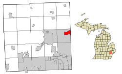
 Location of Rochester, Michigan |
|
| Coordinates: 42°40′50″N 83°08′02″W / 42.68056°N 83.13389°WCoordinates: 42°40′50″N 83°08′02″W / 42.68056°N 83.13389°W | |
| Country | United States |
| State | Michigan |
| County | Oakland |
| Government | |
| • Type | Council-Manager |
| • Mayor | Cathy Aragona-Daldin |
| • City Manager | Jaymes A. Vettraino |
| Area | |
| • Total | 3.83 sq mi (9.92 km2) |
| • Land | 3.83 sq mi (9.92 km2) |
| • Water | 0 sq mi (0 km2) |
| Elevation | 751 ft (229 m) |
| Population (2010) | |
| • Total | 12,711 |
| • Estimate (2012) | 12,889 |
| • Density | 3,318.8/sq mi (1,281.4/km2) |
| Time zone | EST (UTC-5) |
| • Summer (DST) | EDT (UTC-4) |
| ZIP code | 48307 |
| Area code(s) | 248, 947 |
| FIPS code | 26-69020 |
| GNIS feature ID | 0636069 |
| Website | www.ci.rochester.mi.us |
Rochester is a city on the northern outskirts of Metro Detroit, in northeast Oakland County, in the U.S. state of Michigan. The population was 12,711 at the 2010 census. The area is locally known for its active downtown, high-end shopping and dining, rolling hills and large homes.
The city has the following neighborhoods:
The first settlers in what would become Rochester, the Graham family, built a log cabin in 1817. The cabin was located where the Quik Pik and Penn Station stores today exist at the intersection of Main and Second Street. The city was named for Rochester, New York, just like Rochester, Minnesota, as many early settlers to the area were formerly from the state of New York.
The city became an industrial center with abundant water power from the Clinton River and Paint Creek. The interconnected waterways are no longer used for travel or local industry, but provide natural beauty, some fishing, and a healthy portion of the Clinton Watershed. Historically, past industries formerly located in Rochester included a refinery for sugar beets, a paper products company, and the Western Knitting Mills factory, which was later adapted and utilized during World War II for incendiary production—businesses that no longer exist in the area. Rochester was served by two railroads as well as the Detroit United Railway, an interurban to Royal Oak and Detroit.
Chapman Mill Pond, east of downtown, disappeared into the Paint Creek when the dam broke during the flood of 1946. The reclaimed land is the site of the current post office, Rochester Hills library, and Olde Towne Road. Water Street, formerly situated at the edge of the large pond, remains by its name a reminder of the pond's former existence.
Michigan became the 26th state in 1837, and the Village of Rochester was formed on April 12, 1869, within the boundaries of Avon Township. By 1895, Rochester's population was 900. The village became the city of Rochester in 1967, breaking away from Avon Township. Avon Township became the City of Rochester Hills in 1984, following a long court battle, where the city of Rochester annexed 2.2 square miles (5.7 km2) of Avon Township's land. It more than doubled the city of Rochester's size.
...
Wikipedia
