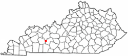
Rochester, Kentucky
| Rochester, Kentucky | |
|---|---|
| City | |
 Location of Rochester within Kentucky |
|
| Coordinates: 37°12′39″N 86°53′33″W / 37.21083°N 86.89250°WCoordinates: 37°12′39″N 86°53′33″W / 37.21083°N 86.89250°W | |
| Country | United States |
| State | Kentucky |
| County | Butler |
| Area | |
| • Total | 0.5 sq mi (1.3 km2) |
| • Land | 0.5 sq mi (1.2 km2) |
| • Water | 0.04 sq mi (0.1 km2) 5.46% |
| Elevation | 410 ft (125 m) |
| Population (2010) | |
| • Total | 152 |
| • Density | 327/sq mi (126.1/km2) |
| Time zone | CST (UTC-6) |
| • Summer (DST) | CDT (UTC-5) |
| ZIP code | 42273 |
| Area code(s) | 270 & 364 |
| FIPS code | 21-65982 |
| GNIS feature ID | 0502100 |
Rochester is a city in Butler County, Kentucky, United States, at the confluence of the Green and Mud rivers. The population was 152 at the 2010 census.
Rochester was incorporated in 1839. It is named for Rochester, New York.
Rochester is located in western Butler County at 37°12′39″N 86°53′33″W / 37.21083°N 86.89250°W (37.210712, -86.892483). Its northwestern boundary, the Green River, is the county boundary as well, with Ohio County on the opposite side of the river. A small portion of the western boundary of the city is formed by the Mud River, which is also the boundary with Muhlenberg County. Kentucky Route 70 (Rochester Road) passes through the city, leading east 14 miles (23 km) to Morgantown, the Butler County seat, and west 10 miles (16 km) to Drakesboro. Kentucky Route 369 leaves Rochester to the north, crossing the Green River by the Rochester Ferry and leading north 14 miles (23 km) to Beaver Dam.
According to the United States Census Bureau, Rochester has a total area of 0.50 square miles (1.3 km2), of which 0.027 square miles (0.07 km2), or 5.46%, is water.
...
Wikipedia
