Muhlenberg County, Kentucky
| Muhlenberg County, Kentucky | |
|---|---|

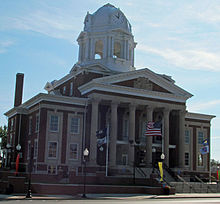
Muhlenberg County Courthouse in Greenville
|
|
 Location in the U.S. state of Kentucky |
|
 Kentucky's location in the U.S. |
|
| Founded | 1798 |
| Named for | John Peter Muhlenberg |
| Seat | Greenville |
| Largest city | Central City |
| Area | |
| • Total | 479 sq mi (1,241 km2) |
| • Land | 467 sq mi (1,210 km2) |
| • Water | 12 sq mi (31 km2), 2.6% |
| Population | |
| • (2010) | 31,839 |
| • Density | 67/sq mi (26/km²) |
| Congressional district | 1st |
| Time zone | Central: UTC-6/-5 |
| Website | www |
Muhlenberg County (/ˈmjuːlənbərɡ/) is a county located in the U.S. Commonwealth of Kentucky. As of the 2010 census, the population was 31,499. Its county seat is Greenville. The county was founded in 1798 and named for General Peter Muhlenberg, a colonial general during the American Revolutionary War.
Muhlenberg County was established in 1798 from land given by Logan and Christian counties. Muhlenberg was the 34th Kentucky county in order of formation.
According to the U.S. Census Bureau, the county has a total area of 479 square miles (1,240 km2), of which 467 square miles (1,210 km2) is land and 12 square miles (31 km2) (2.6%) is water.
The two primary aquatic features of Muhlenberg County are the Green River and Lake Malone. The northern portion of the county is typically gently rolling hills, river flatlands, and some sizeable bald cypress swamps along Cypress Creek and its tributaries. The southern portion consist of rolling hills with higher relief. Many of the valleys in the southern part of the county are rather deep and in places and somewhat rugged. This area is also known for many sandstone formations and some small limestone caves, of which only two known limestone caves are thought to be in the county, both in the far southern region. A number of faults cross the county at roughly the half-way point between neighboring counties to the north and south. Coal is a large natural resource found in the central part of the county. Most deposits reside deep underground, though in the past deposits were closer to the surface. In former years, it was common to see machines such as the "Big Brother" Power Shovel (pictured on the right) throughout the county. During the 1970s and early 1980s, Muhlenberg County was the state leader in Coal Production and sometimes the top coal producer in the United States. This was the subject of the song "Paradise".
...
Wikipedia
