Riverton, Kansas
| Riverton, Kansas | |
|---|---|
| Census-designated place | |
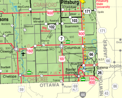
 KDOT map of Cherokee County (legend) |
|
| Location within the state of Kansas | |
| Coordinates: 37°04′30″N 94°42′17″W / 37.07500°N 94.70472°WCoordinates: 37°04′30″N 94°42′17″W / 37.07500°N 94.70472°W | |
| Country |
|
| State |
|
| County | Cherokee |
| Area | |
| • Total | 2.30 sq mi (5.95 km2) |
| • Land | 2.24 sq mi (5.81 km2) |
| • Water | 0.05 sq mi (0.14 km2) |
| Elevation | 833 ft (254 m) |
| Population (2010) | |
| • Total | 929 |
| • Density | 414/sq mi (159.8/km2) |
| Time zone | Central (CST) (UTC-6) |
| • Summer (DST) | CDT (UTC-5) |
| Area code(s) | 620 |
| FIPS code | 20-60200 |
| GNIS feature ID | 0469345 |
Riverton is an unincorporated community and census-designated place in Cherokee County, Kansas, United States. It is located at the junction of K-66 (former U.S. Route 66) and U.S. Route 69 Alternate and U.S. Route 400, near the Spring River. It is one of only three towns in Kansas along former U.S. Route 66. As of the 2010 census, the CDP population was 929.
The first post office in Riverton was established in 1919.
Riverton is located in southeastern Cherokee County near the southeastern corner of Kansas. Along K-66, Galena, Kansas, is 3.5 miles (5.6 km) to the east, and Joplin, Missouri, is 10 miles (16 km) to the east. Pittsburg, Kansas, is 23 miles (37 km) to the north via US 400 and US 69. Baxter Springs, Kansas, is 4.5 miles (7.2 km) to the southwest, and Miami, Oklahoma, is 20 miles (32 km) to the southwest by US 69A.
The eastern and southern edges of the CDP ars formed by the Spring River, which flows south to the Neosho River in Oklahoma. The CDP of Lowell is to the south across the Spring River.
The famous Rainbow Bridge, about 2 miles (3 km) west of town, was the site where in the year 2000, musician Brad Paisley performed the song "(Get Your Kicks on) Route 66" for the TLC special "Route 66: Main Street America".
...
Wikipedia

