Risca
Risca
|
|
|---|---|
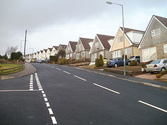
 A view of Risca |
|
| Risca shown within Caerphilly | |
| Population | 11,455 |
| OS grid reference | ST245905 |
| Principal area | |
| Country | Wales |
| Sovereign state | United Kingdom |
| Post town | NEWPORT |
| Postcode district | NP11 |
| Dialling code | 01633 |
| Police | Gwent |
| Fire | South Wales |
| Ambulance | Welsh |
| EU Parliament | Wales |
| UK Parliament | |
| Welsh Assembly | |
Risca (Welsh: Rhisga) is a town of approximately 11,500 people in south-east Wales, within the Caerphilly County Borough and the historic boundaries of Monmouthshire. It is today part of the Newport conurbation (which as a whole has a population of 140,200), though it is not a Ward of Newport City Council. Risca has a railway station, opened on the Ebbw Valley Railway in February 2008, after a gap of 46 years.
The town lies at the south-eastern edge of the South Wales Coalfield and the town has been shaped by mining, together with other heavy industries, for many centuries.
Risca is home to Ty-Sign, which is a large housing estate built in the early 1960s as a satellite village for the then new Llanwern steelworks. Risca has a rural aspect and is surrounded to the east and west by several extensively wooded hills including Mynydd Machen (1,188 ft/362m) and Twmbarlwm (1,375 ft/419m) which attract tourists for the hillwalking and mountain bikers to Cwmcarn Forest Drive.
There is evidence of human habitation in the Risca area going back thousands of years, such as the Silures hillfort on nearby Twmbarlwm, however the area was rural and sparsely populated until the nineteenth century. As local industries expanded and transport links improved with the building of the canal and railways, the population rapidly increased.
...
Wikipedia

