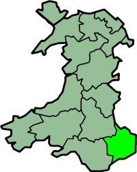
Monmouthshire (historic)
| Monmouthshire Welsh: Sir Fynwy |
|
|---|---|
 Flag adopted in 2011 |
|
 Monmouthshire shown within Great Britain  Monmouthshire shown as a county of Wales |
|
| Area | |
| • 1831 | 324,310 acres (1,312.4 km2) |
| • 1901 | 345,048 acres (1,396.36 km2) |
| • 1961 | 339,088 acres (1,372.24 km2) |
| • 2011 | 346,735 acres (1,403.19 km2) |
| Population | |
| • 1831 | 98,130 |
| • 1901 | 230,806 |
| • 1961 | 444,679 |
| • 2011 | 503,917 |
| Density | |
| • 1831 | 0.3/acre |
| • 1901 | 0.7/acre |
| • 1961 | 1.3/acre |
| • 2011 | 1.45/acre |
| History | |
| • Origin | Laws in Wales Act 1535 |
| • Created | 1535 |
| • Succeeded by | Gwent, Mid Glamorgan, South Glamorgan |
| Status |
Historic county Ceremonial county (until 1974) Administrative county (1889–1974) |
| Chapman code | MON |
| Government | Monmouthshire County Council (1889-1974) Newport County Borough Council (1891-1974) |
| • HQ | Monmouth and Newport |
| • Motto | Faithful to both (Utrique Fidelis) |
 Coat of arms of Monmouthshire County Council |
|
Monmouthshire (/ˈmɒnməθʃər/ or /ˈmɒnməθʃɪər/), also known as the County of Monmouth (/ˈmɒnməθ/; Welsh: Sir Fynwy), is one of thirteen historic counties of Wales and a former administrative county.
It corresponds approximately to the present principal areas of Monmouthshire, Blaenau Gwent, Newport and Torfaen, and those parts of Caerphilly and Cardiff east of the Rhymney River.
...
Wikipedia
