Rio del Mar
| Rio del Mar | |
|---|---|
| census-designated place | |
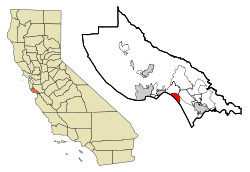
 Location in Santa Cruz County and the state of California |
|
| Location in the United States | |
| Coordinates: 36°57′50″N 121°53′16″W / 36.96389°N 121.88778°WCoordinates: 36°57′50″N 121°53′16″W / 36.96389°N 121.88778°W | |
| Country |
|
| State |
|
| County | Santa Cruz |
| Area | |
| • Total | 4.612 sq mi (11.945 km2) |
| • Land | 3.001 sq mi (7.772 km2) |
| • Water | 1.611 sq mi (4.173 km2) 34.94% |
| Elevation | 144 ft (44 m) |
| Population (2010) | |
| • Total | 9,216 |
| • Density | 2,000/sq mi (770/km2) |
| Time zone | PST (UTC-8) |
| • Summer (DST) | PDT (UTC-7) |
| ZIP code | 95003 |
| Area code(s) | 831 |
| FIPS code | 06-60928 |
| GNIS feature ID | 1659513 |
Rio del Mar (From Spanish: Río del Mar, meaning River of the Sea) is a census-designated place (CDP) in Santa Cruz County, California, United States. The name "Rio Del Mar" was chosen as a "catchy" name to promote real estate in the area during the 1920s. There is no body of water by that name in Santa Cruz County. But there is a large creek, Aptos Creek, that goes through Rio del Mar and empties into the Monterey Bay at Rio del Mar. Aptos Creek is the "Rio" in Rio del Mar. The population was 9,216 at the 2010 census.
Rio del Mar is located at 36°57′50″N 121°53′16″W / 36.96389°N 121.88778°W (36.963764, -121.887690).
According to the United States Census Bureau, the CDP has a total area of 4.6 square miles (12 km2), of which, 3.0 square miles (7.8 km2) of it is land and 1.6 square miles (4.1 km2) of it (34.94%) is water.
The 2010 United States Census reported that Rio del Mar had a population of 9,216. The population density was 1,998.3 people per square mile (771.5/km²). The racial makeup of Rio del Mar was 8,310 (90.2%) White, 61 (0.7%) African American, 50 (0.5%) Native American, 313 (3.4%) Asian, 7 (0.1%) Pacific Islander, 188 (2.0%) from other races, and 287 (3.1%) from two or more races. Hispanic or Latino of any race were 899 persons (9.8%).
...
Wikipedia

