Rio Negro (Argentina)
| Negro | |
| Curú Leuvú, Río de los Sauces | |
| River | |
|
Rio Negro near the mouth, between the cities of Viedma, Río Negro and Carmen de Patagones, Buenos Aires
|
|
| Country | Argentina |
|---|---|
| States | Neuquén, Río Negro, Buenos Aires |
| Region | Patagonia |
| Tributaries | |
| - left | Neuquén River |
| - right | Limay River |
| Cities | Neuquén, Villa Regina |
| Primary source | Limay River |
| - location | Nahuel Huapi Lake, Neuquén & Río Negro |
| - elevation | 770 m (2,526 ft) |
| - coordinates | 41°03′20″S 71°09′07″W / 41.05556°S 71.15194°W |
| Secondary source | Neuquén River |
| - location | Near Laguna Fea, Neuquén |
| - elevation | 2,800 m (9,186 ft) |
| - coordinates | 36°10′53″S 70°34′16″W / 36.18139°S 70.57111°W |
| Source confluence | |
| - location | Neuquén, Río Negro & Neuquén |
| - elevation | 250 m (820 ft) |
| - coordinates | 38°59′40″S 68°00′07″W / 38.99444°S 68.00194°W |
| Mouth | Atlantic Ocean |
| - location | El Cóndor, Río Negro & Buenos Aires |
| - elevation | 0 m (0 ft) |
| - coordinates | 41°01′50″S 62°47′23″W / 41.03056°S 62.78972°WCoordinates: 41°01′50″S 62°47′23″W / 41.03056°S 62.78972°W |
| Length | 550 km (342 mi) |
| Basin | 102,000 km2 (39,382 sq mi) |
| Discharge | for Primera Angostura |
| - average | 762.5 m3/s (26,927 cu ft/s) |
| - max | 2,068 m3/s (73,031 cu ft/s) |
| - min | 181 m3/s (6,392 cu ft/s) |
|
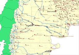
Northern Patagonia, main rivers, and political divisions and main cities.
|
|
Río Negro (Spanish pronunciation: [ˈri.o ˈneɣɾo]; Black River) is the most important river of the Argentine province of Río Negro.
It originates from the junction of the Limay River and Neuquén River at the border with the Neuquén Province, and flows southeast to the Atlantic Ocean at 41°01′20″S 62°47′25″W / 41.0223°S 62.7903°W, near El Cóndor beach resort some 30 kilometres (19 mi) downstream from Viedma, Río Negro province's capital.
The river allows the Río Negro province to produce 65% of the pears and apples of Argentina. Besides irrigation, the river is also source of hydroelectricity with small dams on its course.
The river served as natural demarcation between "civilization" and the aboriginal territories during the Conquest of the Desert of late 19th century.
The river is divided into three parts: The Alto Valle (High Valley) near the beginning of the river, Valle Medio (Medium Valley) near Choele Choel, and Valle Inferior (Lower Valley) near its end.
...
Wikipedia


