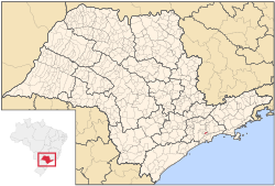
Rio Grande da Serra
| Rio Grande da Serra | |||
|---|---|---|---|
|
|||
 Location of Rio Grande da Serra |
|||
| Location of Rio Grande da Serra | |||
| Coordinates: 23°44′38″S 46°23′52″W / 23.74389°S 46.39778°WCoordinates: 23°44′38″S 46°23′52″W / 23.74389°S 46.39778°W | |||
| Country |
|
||
| Region | Southeast | ||
| State |
|
||
| Government | |||
| • Mayor | Adler Alfredo Jardim Teixeira (PSDB) | ||
| Area | |||
| • Total | 36.34 km2 (14.03 sq mi) | ||
| Elevation | 780 m (2,560 ft) | ||
| Population (2015) | |||
| • Total | 48,302 | ||
| • Density | 1,300/km2 (3,400/sq mi) | ||
| Time zone | BRT (UTC-3) | ||
| • Summer (DST) | BRST (UTC-2) | ||
| HDI (2000) | 0.764 – medium | ||
| Website | Rio Grande da Serra | ||
Rio Grande da Serra is a municipality in the state of São Paulo in Brazil. It is located approximately 49 kilometres (30 mi) by road southeast of the centre of the city of São Paulo. It is part of the Metropolitan Region of São Paulo. The population is 48,302 (2015 est.) in an area of 36.34 km².
The earliest date recorded in the history of Rio Grande da Serra is May 26, 1560 when land was allotted in Jeribatiba, the third village developed by the Jesuits. To meet local needs, salt had to be brought from the port of São Vicente up to the Alto da Serra highlands via the village now known as Paranapiacaba. In 1640, the Marquês de Alegretti officially renamed Jeribatiba "Rio Grande". The mode of transport was donkeys during that period and Mogi das Cruzes, founded in 1640, rapidly became the largest settlement. Salt was transported along the so-called Caminho do Mar (sea road) to Alto da Serra, also locally known as Zanzaláh. One of the Jesuits who died on this route was buried with a wooden cross which in 1611 was converted into a chapel, now known as the Capela de São Sebastião.
In 1840, General Antônio Manuel de Melo built a ranch on the road from Mogi das Cruzes to São Paulo. In 1855, a cholera epidemic caused devastation in the region.
Until the nineteenth century, the inhabitants had been engaged in pastoral activities. On February 16, 1867, the São Paulo Railway reached Rio Grande, enabling coffee beans and timber to be transported to São Paulo. As a result, the development of Rio Grande boomed, However. it also resulted in the influx of expatriates mostly from England who established a new town at Paranapiacaba, a few miles away. The railroad encouraged the development of coal mining from 1880 and by 1895, that of manganese and graphite extraction and as well as mineral water. Expatriates from Italy, Germany and Switzerland came to work at Rio Grande from 1899 onwards.
Work on the canalization of the Rio Grande river was initiated in 1906. In 1918, graphite industry was established. 1920 marked the first telephone connection. In 1927, São Paulo municipality acquired Pedreira, a suburb of Rio Grande, bringing new factories with opportunities for employment. In 1928, an electric power station was built. Between 1930 and 1954 many small scale industries, extensive housing facilities, marketing centers and factories manufacturing all types of goods were set up. Schools, sports centers, musical events, carnivals and religious festivals emerged. After all these developments the town, Rio Grande da Serra, was given the status of municipality in 1964. Population growth in Rio Grande da Serra was slow until the mid-1970s, when there was an influx of migrants, mostly miners which has lasted until today, although the increase is now falling.
...
Wikipedia


