Paranapiacaba
| Paranapiacaba | |
|---|---|

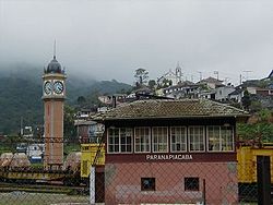
A view of Paranapiacaba village, in Santo André, Brazil.
|
|
| Coordinates: 23°46′40.8″S 46°18′9.0″W / 23.778000°S 46.302500°WCoordinates: 23°46′40.8″S 46°18′9.0″W / 23.778000°S 46.302500°W | |
| Country |
|
| Region | Southeast |
| State |
|
| Time zone | UTC-3 (UTC-3) |
| • Summer (DST) | UTC-2 (UTC-2) |
Paranapiacaba is a district of the municipality of Santo André in the Brazilian state of São Paulo. It is located approximately 61 kilometres (38 mi) by road southeast of the centre of the city of São Paulo, and about 12 kilometres (7.5 mi) east of Rio Grande da Serra. The word paranapiacaba means "where you will find the sea" in Tupi. There are about 1,200 residents.
Paranapiacaba was established as a company town for the employees of São Paulo Railway, a privately owned British railway company. A large industrial complex, which the district is known for, lies off the main road from Rio Grande da Serra, on the way into the main village. The growth of this centre was facilitated by the railway, transporting cargo and people from inside Paulista to the port of Santos. The village design has been characterized as being panoptic.
The village is located on a slope opposite Santo André, approximately 61 kilometres (38 mi) by road southeast of the centre of the city of São Paulo, and about 12 kilometres (7.5 mi) east of Rio Grande da Serra. The industrial complex, larger than the village itself, however, lies just several kilometres to the southeast of Rio Grande da Serra. The village is located amidst the Serra do Mar coastal forests, in the south coast, at the highest point of the area, and hence it came to be known as “a place to view the sea” in Tupi-Guarani language. The Mata Atlantica around the town provides ample opportunities for hiking into the forest of the Parque Estadual da Serra do Mar where orchids and bromelias are major attractions. Agriculture and grazing farms are situated to the west while the nearby mountains reach elevations of 700–930 metres (2,300–3,050 ft).
...
Wikipedia
