Ribérac
| Ribérac | ||
|---|---|---|

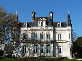
Town hall
|
||
|
||
| Coordinates: 45°14′52″N 0°20′23″E / 45.2478°N 0.3397°ECoordinates: 45°14′52″N 0°20′23″E / 45.2478°N 0.3397°E | ||
| Country | France | |
| Region | Nouvelle-Aquitaine | |
| Department | Dordogne | |
| Arrondissement | Périgueux | |
| Canton | Ribérac | |
| Government | ||
| • Mayor (2014–2020) | Patrice Favard | |
| Area1 | 22.79 km2 (8.80 sq mi) | |
| Population (2008)2 | 4,125 | |
| • Density | 180/km2 (470/sq mi) | |
| Time zone | CET (UTC+1) | |
| • Summer (DST) | CEST (UTC+2) | |
| INSEE/Postal code | 24352 /24600 | |
| Elevation | 54–155 m (177–509 ft) (avg. 68 m or 223 ft) |
|
|
1 French Land Register data, which excludes lakes, ponds, glaciers > 1 km² (0.386 sq mi or 247 acres) and river estuaries. 2Population without double counting: residents of multiple communes (e.g., students and military personnel) only counted once. |
||
1 French Land Register data, which excludes lakes, ponds, glaciers > 1 km² (0.386 sq mi or 247 acres) and river estuaries.
Ribérac (Occitan: Rabairac) is a commune in the Dordogne department in Nouvelle-Aquitaine in southwestern France. The commune is situated by the Dronne River.
In 1793, the commune of Faye joined with Ribérac. In 1851, a part of the commune was dismembered for the creation of the new commune of Saint-Martin-de-Ribérac. Ribérac was the old sub-prefecture that was removed in a decree of 10 September 1926.
...
Wikipedia


