Rheden
| Rheden | |||
|---|---|---|---|
| Municipality | |||

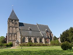
Church in Rhenen
|
|||
|
|||
 Location in Gelderland |
|||
| Coordinates: 52°1′N 6°3′E / 52.017°N 6.050°ECoordinates: 52°1′N 6°3′E / 52.017°N 6.050°E | |||
| Country | Netherlands | ||
| Province | Gelderland | ||
| Government | |||
| • Body | Municipal council | ||
| • Mayor | Petra van Wingerden-Boers (VVD) | ||
| Area | |||
| • Total | 84.35 km2 (32.57 sq mi) | ||
| • Land | 81.76 km2 (31.57 sq mi) | ||
| • Water | 2.59 km2 (1.00 sq mi) | ||
| Elevation | 28 m (92 ft) | ||
| Population (May 2014) | |||
| • Total | 43,561 | ||
| • Density | 533/km2 (1,380/sq mi) | ||
| Demonym(s) | Rhedenaar | ||
| Time zone | CET (UTC+1) | ||
| • Summer (DST) | CEST (UTC+2) | ||
| Postcode | 6880–6883, 6950–6957, 6990–6994 | ||
| Area code | 026, 0313 | ||
| Website | www |
||
Rheden (![]() pronunciation ) is a municipality and a town in the eastern Netherlands.
pronunciation ) is a municipality and a town in the eastern Netherlands.
Population of the seven villages on 1 January 2013
Rheden, country house: de Valkenberg
Velp, river: de IJssel
Velp, view to a street (de Hoofdstraat)
Velp, monumental office building at the Hoofdstraat
Dieren, tower: de Dierense toren
Dieren, monumental house: Schweer bey der Beckehof
De Steeg, monumental house at Hoofdstraat 1
Spankeren, reformed church
Dutch Topographic map of the municipality of Rheden, June 2015
...
Wikipedia


