Reynolds, Indiana
| Reynolds, Indiana | |
|---|---|
| Town | |

The Reynolds water tower
|
|
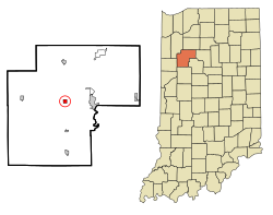
 Location of Reynolds in the state of Indiana |
|
| Coordinates: 40°45′0″N 86°52′25″W / 40.75000°N 86.87361°WCoordinates: 40°45′0″N 86°52′25″W / 40.75000°N 86.87361°W | |
| Country | United States |
| State | Indiana |
| County | White |
| Township | Honey Creek |
| Area | |
| • Total | 0.55 sq mi (1.42 km2) |
| • Land | 0.55 sq mi (1.42 km2) |
| • Water | 0 sq mi (0 km2) |
| Elevation | 699 ft (213 m) |
| Population (2010) | |
| • Total | 533 |
| • Estimate (2012) | 526 |
| • Density | 969.1/sq mi (374.2/km2) |
| Time zone | Eastern (EST) (UTC-5) |
| • Summer (DST) | EDT (UTC-4) |
| ZIP code | 47980 |
| Area code(s) | 219 |
| FIPS code | 18-63918 |
| GNIS feature ID | 441922 |
Reynolds is a town in Honey Creek Township, White County, in the U.S. state of Indiana. The population was 533 at the 2010 census.
Reynolds was platted in 1854 when the railroad was extended to that point. The town was named for Benjamin Reynolds, one of its founders. A post office has been in operation at Reynolds since 1853. Reynolds was incorporated as a town in 1875.
Reynolds is located at 40°45′0″N 86°52′25″W / 40.75000°N 86.87361°W (40.750051, -86.873716).
According to the 2010 census, Reynolds has a total area of 0.55 square miles (1.42 km2), all land.
Mean prices in 2008: All housing units: $189,808; Detached houses: $191,528; Townhouses or other attached units: $186,187; Mobile homes: $116,429
As of the census of 2010, there were 533 people, 215 households, and 151 families residing in the town. The population density was 969.1 inhabitants per square mile (374.2/km2). There were 244 housing units at an average density of 443.6 per square mile (171.3/km2). The racial makeup of the town was 91.4% White, 0.2% African American, 2.1% Native American, 5.3% from other races, and 1.1% from two or more races. Hispanic or Latino of any race were 9.9% of the population.
...
Wikipedia
