Renfrew, Ontario
| Renfrew | |
|---|---|
| Town (lower-tier) | |
| Town of Renfrew | |

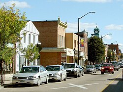
Raglan Street in the centre of Renfrew
|
|
| Location of Renfrew in the province of Ontario | |
| Coordinates: 45°28′18″N 76°40′59″W / 45.47167°N 76.68306°WCoordinates: 45°28′18″N 76°40′59″W / 45.47167°N 76.68306°W | |
| Country |
|
| Province |
|
| County | Renfrew |
| Incorporated | July 27, 1858 |
| Government | |
| • Mayor | Don Eady |
| • Reeve | Peter R. Emon |
| Area | |
| • Land | 12.77 km2 (4.93 sq mi) |
| Population (2011) | |
| • Total | 8,218 |
| • Density | 643.5/km2 (1,667/sq mi) |
| • Dwellings | 3,980 |
| • Pop. Growth | 4.7% from 2,006 |
| Time zone | EST (UTC-5) |
| • Summer (DST) | EDT (UTC-4) |
| Postal code FSA | K7V |
| Area code(s) | 613 & 343 |
| Exchanges | (432, 433, 570 exchange) |
| Highways |
|
| Website | renfrewontario.com renfrewontario.ca |
Renfrew, Ontario, Canada, is a town on the Bonnechere River in Renfrew County. Located one hour west of Ottawa in Eastern Ontario, Renfrew is the third largest town in the county after Petawawa and Pembroke. The town is a small transportation hub connecting Highway 60 and Highway 132 with the Trans-Canada Highway. Renfrew is also known historically for its role in the formation of the National Hockey League. It lies about 5 kilometres from the Quebec border, about 10 kilometres by road.
Named after the town of Renfrew in Scotland, Renfrew was settled largely in part due to logging in the area in the early 19th century, where the river was used in order to drive the lumber to locations such as Ottawa. This heritage was until recently celebrated every July with the Lumber Baron Festival.
Renfrew and the surrounding Township of Horton are at the intersection of the Bonnechere River and the Ottawa River in the Ottawa Valley. Renfrew is at the intersection of provincial Highway 17, Highway 60, and Highway 132.
Primary Schools (Grade K-6)
Middle School (Grade 7-8)
Secondary School (Grade 9-12)
Primary Schools
Secondary School (Grade 8-12)
...
Wikipedia

