Región del Biobío
|
Bío Bío Region Región del Biobío |
|||
|---|---|---|---|
| Region of Chile | |||
 |
|||
|
|||
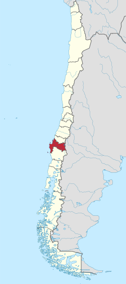
 Map of Bío Bío Region |
|||
| Coordinates: 36°50′S 73°03′W / 36.833°S 73.050°WCoordinates: 36°50′S 73°03′W / 36.833°S 73.050°W | |||
| Country |
|
||
| Capital | Concepción | ||
| Provinces | Ñuble, Bío Bío, Concepción, Arauco | ||
| Government | |||
| • Intendant | Rodrigo Díaz Worner (none) | ||
| Area | |||
| • Total | 37,068.7 km2 (14,312.3 sq mi) | ||
| Area rank | 8 | ||
| Lowest elevation | 0 m (0 ft) | ||
| Population (2014 projection) | |||
| • Total | 2,100,494 | ||
| • Rank | 2 | ||
| • Density | 57/km2 (150/sq mi) | ||
| ISO 3166 code | CL-BI | ||
| Website | Official website (Spanish) | ||
The Bío Bío Region (BEE-oh-BEE-oh; Spanish: Región del Bío-Bío pronounced: [ˌbi.oˈβi.o]), is one of Chile's fifteen first-order administrative divisions; it is divided into four provinces: Arauco, Bío Bío, Concepción, and Ñuble. It is also known by its original denomination: VIII Region. Concepción is the capital and largest city. Other important cities include Chillán, Coronel, Hualpén, Los Ángeles, and Talcahuano.
The Region of the Bío Bío is bordered on the west by the Pacific Ocean, on the east by Argentina, on the north by the Chilean Region of Maule, and on the south by the Chilean Region of Araucanía.
The Region has been hit by many Chilean earthquakes, including the most powerful earthquake ever recorded (in 1960) and the great earthquake of 2010. Many communities in the region were greatly affected by the earthquake of 2010 and the subsequent tsunami. That earthquake damaged Talcahuano and Dichato; the tsunami destroyed much of what remained of the port town.
...
Wikipedia


