Rednal
| Rednal | |
|---|---|
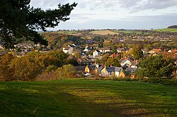
 View from Rednal Hill towards Rubery, with the houses of Rednal in the foreground |
|
| Rednal shown within the West Midlands | |
| Population | 2,000 (2001 Population Census) |
| • Density | 34.8 per ha |
| OS grid reference | SP002772 |
| Metropolitan borough | |
| Metropolitan county | |
| Region | |
| Country | England |
| Sovereign state | United Kingdom |
| Post town | BIRMINGHAM |
| Postcode district | B45 |
| Dialling code | 0121 |
| Police | West Midlands |
| Fire | West Midlands |
| Ambulance | West Midlands |
| EU Parliament | West Midlands |
| UK Parliament | |
Rednal is a residential suburb on the south western edge of metropolitan Birmingham, West Midlands, England, 9 miles (14.2 kilometres) south west of Birmingham city centre and forming part of Longbridge parish and electoral ward.
Rednal is home to approximately 2,000 residents. The suburb is located in a triangle formed by Rubery and the Bristol Road South to the north and north west, the former MG Rover car factory to the south east and the Lickey Hills and Cofton Hackett Park just south. The popular rural Lickey Hills Country Park is half a mile south of Rednal, with Rednal Hill being the nearest peak.
The first evidence of people settling in the area date back to the Stone age when a Neolithic hunter lost a flint arrow head on Rednal Hill. The arrow head is leaf-shaped and made of flint and is certainly over 4000 years old. Additionally a 3000-year-old flint javelin point was found lying on the surface by an observant Mr W. H. Laurie when the Lickey's road-widening was taking place in 1925. A flint scraping tool was found in the area near the Earl of Plymouth monument. The artifacts are on display at Birmingham Museum and Art Gallery.
The Romans constructed a road over the Lickeys very near to the present Rose Hill gap, before it swung north through Rednal and followed the route of the present day Bristol Road South. The road would have been used to transport salt and other goods between the Roman encampments at Worcester and Metchley, near where Birmingham's Queen Elizabeth Hospital now stands. It would have also been used as a military marching route by Roman soldiers. In 1963 a Roman coin was found near Rednal Hill School by a Janet and Stephen Harris. The coin was a dupondius struck during the reign of the Emperor Antoninus Pius who ruled Rome and Britain from 138 to 161. The tiny coin was struck from brass and would have been worth about the price of a loaf of bread.
...
Wikipedia

