Red Mountain AVA
| Wine region | |
 |
|
| Type | American Viticultural Area |
|---|---|
| Year established | 2001 |
| Country | United States |
| Part of | Columbia Valley AVA, Washington, Yakima Valley AVA |
| Growing season | 180 days |
| Climate region | Continental |
| Precipitation (annual average) | 6 to 8 inches (15 to 20 cm) |
| Total area | 4,040 acres (1,630 ha) |
| Size of planted vineyards | 710 acres (290 ha) |
| Grapes produced | Cabernet Franc, Cabernet Sauvignon, Chardonnay, Counoise, Gewurztraminer, Lemberger, Malbec, Merlot, Mourvedre, Nebbiolo, Petit Verdot, Pinot gris, Riesling, Roussanne, Sauvignon blanc, Semillon, Syrah, Viognier |
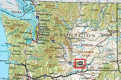
The Red Mountain AVA is an American Viticultural Area that includes the land surrounding Red Mountain in Benton County, Washington. It is part of the Yakima Valley AVA, which in turn is part of the larger Columbia Valley AVA. Located between Benton City and the City of West Richland, the Red Mountain AVA is the smallest in the state at only 4,040 acres (1,630 ha) in area. The area has 600 acres (240 ha) under cultivation of primarily red varietals including Cabernet Sauvignon, Merlot, Sangiovese, Cabernet Franc and Syrah. The reputation of the wines produced in this area has brought Red Mountain AVA worldwide acclaim. The vineyards in this appellation have produced grapes for some of the most sought after wines in Washington State.
The Missoula floods, a series of massive floods that occurred at the end of the last Ice Age, profoundly affected the soils of Red Mountain. The fast travelling flood waters, estimated at 390 meters tall, would sweep around the east and west edges of Red Mountain, creating powerfully back-eddies. As a result of the back-eddies, sediments were deposited in an irregular manner, creating a heterogeneous soil with a series of gravel lenses. In the 10,000 years since the Missoula floods, wind-blown loess was deposited, creating a thin mantle of dunes that vary in thickness throughout Red Mountain. This has created a series of soils that differ from those of the immediately surrounding area.
The geography to the northeast features part of the Columbia Basin lowlands where the Columbia River turns southward towards the Saddle Mountains. With elevations ranging from 500 feet (152 m) to 1,500 feet (457 m), the landscape today dominates this area of the lower Yakima Valley. The red color in the name comes from the dark red springtime hue of the drooping brome or "cheatgrass" in the area. The soil in the area is very gravelly, with high alkalinity (high pH) and calcium carbonate content.
...
Wikipedia
