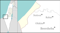
Re'im
|
Re'im רֵעִים |
|
|---|---|
| Coordinates: 31°23′9.95″N 34°27′37.07″E / 31.3860972°N 34.4602972°ECoordinates: 31°23′9.95″N 34°27′37.07″E / 31.3860972°N 34.4602972°E | |
| District | Southern |
| Council | Eshkol |
| Affiliation | Kibbutz Movement |
| Founded | 1949 |
| Founded by | Scouts Federation and former Palmach members |
| Population (2015) | 403 |
| Name meaning | Friends |
| Website | www.reim.org.il |
Re'im (Hebrew: רֵעִים, lit. Friends) is a secular kibbutz in southern Israel, and one of the Gaza vicinity villages. Located at the confluence of Besor Stream and Gerar Stream in the north-western Negev desert, it falls under the jurisdiction of Eshkol Regional Council. In 2015 it had a population of 403.
Re'im was founded in 1949 by members of the Israel Boy and Girl Scouts Federation who were demobilized from the Palmach. The kibbutz changed names several times before taking its current name.
Re'im is located between roads 232 and 234 in the western Negev, next to the Re'im Junction and Gama Junction. The ruins of ancient Gama (Tell Jemmeh) are located to the west of the kibbutz. West of Re'im is the kibbutz Kissufim, and north is Be'eri. Re'im's elevation is 50 m above sea level, and the Besor Stream passes through its territory.
The kibbutz was established in 1949 by former Palmach members with the provisional name HaTzofim Vav (lit. Scouts F). It was then named Tel Re'im (Hebrew: תל רעים, lit. Hill of Friends) after the Arabic translation of the nearby archaeological site of Tell Jemmeh. It was eventually renamed Re'im in memory of members of the Gar'in who were killed in the 1948 Arab-Israeli War. The name, meaning 'friends', was taken from the Book of Proverbs (18:24) to symbolize them.
...
Wikipedia

