Raymond Terrace
|
Raymond Terrace New South Wales |
|||||||||||||
|---|---|---|---|---|---|---|---|---|---|---|---|---|---|

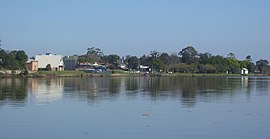
Raymond Terrace foreshore from the Fitzgerald bridge
|
|||||||||||||
| Coordinates | 32°45′41.3″S 151°44′38.6″E / 32.761472°S 151.744056°ECoordinates: 32°45′41.3″S 151°44′38.6″E / 32.761472°S 151.744056°E | ||||||||||||
| Population | 12,725 (2011 census) | ||||||||||||
| • Density | 515.2/km2 (1,334/sq mi) | ||||||||||||
| Established | 1837 | ||||||||||||
| Postcode(s) | 2324 | ||||||||||||
| Elevation | 6 m (20 ft) | ||||||||||||
| Area | 39.7 km2 (15.3 sq mi) | ||||||||||||
| Time zone | AEST (UTC+10) | ||||||||||||
| • Summer (DST) | AEDT (UTC+11) | ||||||||||||
| Location | |||||||||||||
| LGA(s) | Port Stephens Council | ||||||||||||
| Region | Hunter, Mid North Coast | ||||||||||||
| County | Gloucester | ||||||||||||
| Parish | Eldon | ||||||||||||
| State electorate(s) | |||||||||||||
| Federal Division(s) | Paterson | ||||||||||||
|
|||||||||||||
Raymond Terrace is a town in the Hunter Region of New South Wales, Australia, about 26 km (16 mi) by road north of Newcastle on the Pacific Highway. Established in 1837 it is situated at the confluence of the Hunter and Williams rivers. The town was named after Lieutenant Raymond, who had explored the Hunter River in 1797 and described the terraced appearance of trees in the area.Governor Lachlan Macquarie camped in the area in 1818, using "Raymond Terrace" as the name for the place where his party had camped.
At the 2011 census Raymond Terrace had a population of 12,725. It is the administrative centre of the Port Stephens local government area as well as a service hub for surrounding rural areas.
Raymond Terrace is situated to the east of the Hunter and Williams rivers and consists of three distinct regions. The north and south regions are primarily rural/semi-rural and occupy approximately 74% of the town's land with only 3% of the population living in these areas. Most of the population lives in the town itself.
The centre of the town, where the shopping district is located, is adjacent to the Hunter River, just south of the confluence of the two rivers. Access to the northern sides of the rivers is via the Fitzgerald bridge which crosses the Williams River immediately adjacent to and upstream of the confluence. When the Hunter River is in flood, access beyond the Fitzgerald Bridge to the northern side of the Williams River (i.e. to Nelsons Plains) is often not possible due to its low-lying nature. The town of Raymond Terrace is mostly protected by levee banks and other flood mitigation devices. However, some lower parts of the town still flood, as happened during the June 2007 Hunter Region and Central Coast storms.
...
Wikipedia

