Rausu, Hokkaidō
|
Rausu 羅臼町 |
|
|---|---|
| Town | |

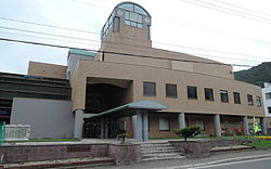
Rausu town hall
|
|
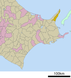
 Location of Rausu in Hokkaido (Nemuro Subprefecture) |
|
| Location in Japan | |
| Coordinates: 44°1′N 145°11′E / 44.017°N 145.183°ECoordinates: 44°1′N 145°11′E / 44.017°N 145.183°E | |
| Country | Japan |
| Region | Hokkaido |
| Prefecture | Hokkaido (Nemuro Subprefecture) |
| District | Menashi |
| Area | |
| • Total | 397.88 km2 (153.62 sq mi) |
| Population (March 31, 2008) | |
| • Total | 6,202 |
| • Density | 16/km2 (40/sq mi) |
| Time zone | Japan Standard Time (UTC+9) |
| Website | www |
Rausu (羅臼町 Rausu-chō?) is a town located in Menashi District, Nemuro Subprefecture, Hokkaido, Japan. As of March 31, 2008 it has an estimated population of 6,202 and an area of 397.88 km2.
The word “Rausu” originates from the Ainu word raushi, roughly meaning “Low-land” or “Place of men with beast-like spirit.”
The town occupies the southern half of the Shiretoko Peninsula. Kunashir Island, one of the four disputed Kuril Islands, can be seen from the town.
Rausu is located on the east end of Hokkaido’s Shiretoko Peninsula. It is situated on the southeast corner of the peninsula facing the Nemuro Strait. The town stretches along and narrow strip of land, extending 64 km (40 mi) from southwest to northeast. The Shiretoko mountain range extends north on the peninsula to the sea where it forms steep cliffs. The Shiretoko mountain range is the source for myriad rivers, that all empty into the sea. Village communities are found mostly on the coast line at the mouths of these rivers. The “downtown” of Rausu is at the mouth of Rausu River where it joins the sea at Rausu Harbor.
Two access points to Rausu via highway are through Shibetsu in the south or through Shari on the west side of the Shiretoko Peninsula. From Shibetsu, National Highway 335(the Kunashiri Highway)extends northwards along the coast into Rausu at which point it crosses the peninsula heading west, over the Shiretoko mountain range (the Shiretoko Pass). The Shiretoko Pass leads into Shari and becomes National Highway 334 (Shiretoko Crossing). Some sections of both highways (334 & 335) feature steep precipices just off the shoulder and may prove dangerous. There are also a number of tunnels along both highways. Rausu is about 70 km (43 mi) northeast from Nakashibetsu airport. It is 120 km (75 mi) northeast of Kushiro City.
...
Wikipedia

