Rauris
| Rauris | |
|---|---|
 |
|
| Location within Austria | |
| Coordinates: 47°13′45″N 12°59′40″E / 47.22917°N 12.99444°ECoordinates: 47°13′45″N 12°59′40″E / 47.22917°N 12.99444°E | |
| Country | Austria |
| State | Salzburg |
| District | Zell am See |
| Government | |
| • Mayor | Peter Loitfellner (SPÖ) |
| Area | |
| • Total | 233.02 km2 (89.97 sq mi) |
| Elevation | 950 m (3,120 ft) |
| Population (1 January 2016) | |
| • Total | 3,063 |
| • Density | 13/km2 (34/sq mi) |
| Time zone | CET (UTC+1) |
| • Summer (DST) | CEST (UTC+2) |
| Postal code | 5661 |
| Area code | 06544 |
| Vehicle registration | ZE |
| Website | www.rauris.net |
| Rauris Hochalmbahnen | |
|---|---|
| Location | Rauris |
| Coordinates | 47°13′26″N 12°59′30″E / 47.223980°N 12.991583°E |
| Vertical | 1,235 m (4,052 ft) |
| Top elevation | 2,175 m (7,136 ft) |
| Base elevation | 940 m (3,080 ft) |
| Total length | 32 km (20 mi) |
Rauris is a municipality in Salzburg (state) in the area of Pinzgau in Austria. There are about 3,150 inhabitants living in Rauris.
The market town Rauris is located in the Pinzgau in the state Salzburg at the river Rauriser Ache at the bottom of the Sonnblick group in the heart of the Nationalpark Hohe Tauern. Rauris is the largest municipal area of the province of Salzburg.
Bucheben, Fröstlberg, Grub, Hundsdorf, Marktrevier, Rauris, Seidlwinkl, Unterland, Vorstanddorf, Vorstandrevier, Wörth and Wörtherberg are all within the municipal area of Rauris.
The valley of Rauris is one of the lesser valleys in the Tauern that is permanently populated. Archeological findings show that these passes were used by ancient people near the Rauriser Tauern (Hochtor). A gilt neck-ring was found on the Maschlalm which originated from the time of La Tène in about 400 B.C. In the centre of Rauris six silver-coins were found, of which three show the head of Philip II of Macedon, who reigned 360 to 336 B.C. on the Balkan.
Further findings are a small Hercules-statue from Roman-times, a bronze-sword from 1300 B.C., older than a scarab discovered from the time of Ramses II in about 1200 B.C.
The valley was first settled in the south. This began with the founding of Schwaigen in the 12th Century. The present-day place of Rauris was named after the Gaisbach earlier. It was first mentioned in 1120. The name "Rurise" appeared for the first time in 1122, when Bishop Heinrich of Freising handed over two yards to his brother Count Friedrich of Peilstein, and marked the whole valley.
By 1230, Wörth was an important resting point for people and vehicles passing south over the Tauern (Seidlwinkl) to the mining-area in (Hüttwinkl).
The valley of Seidlwinkl was the eastern gateway to the Tauern (Hochtor), its advantage being that it could be open for longer. The importance of the valley led to the construction of the original Rauriser Tauernhaus that gave shelter and warmth to passing tradesmen. Much like the existing pass houses in other valleys. The Rauriser Tauernhaus got the right to sell drinks in 1491.
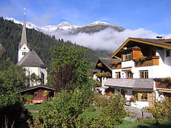
In 1203 the delighted Chrysant of Einöd constructed a chapel in honour of St. Michael. In 1339, the reconstruction of the church was applied for and in just 15 years was completed. In documents from 1411, it has been discovered that the church was reconstructed once again. However, there has only been a consecrated and independent parish of Rauris since 1858. The parish-church of Rauris is called the Church of Saint Martin and Saint Jakob.
...
Wikipedia

