Rastenburg
| Kętrzyn | |||
|---|---|---|---|

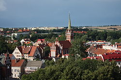
Panorama of the town
|
|||
|
|||
| Coordinates: 54°5′N 21°23′E / 54.083°N 21.383°E | |||
| Country |
|
||
| Voivodeship | Warmian-Masurian | ||
| County | Kętrzyn County | ||
| Gmina | Kętrzyn (urban gmina) | ||
| Established | 1329 | ||
| Town rights | 1357 | ||
| Government | |||
| • Mayor | Krzysztof Hećman | ||
| Area | |||
| • Total | 10.34 km2 (3.99 sq mi) | ||
| Population (2006) | |||
| • Total | 28,000 | ||
| • Density | 2,700/km2 (7,000/sq mi) | ||
| Time zone | CET (UTC+1) | ||
| • Summer (DST) | CEST (UTC+2) | ||
| Postal code | 11-400 | ||
| Area code(s) | +48 89 | ||
| Car plates | NKE | ||
| Website | http://www.ketrzyn.pl/ | ||
Kętrzyn [ˈkɛntʂɨn] (German: Rastenburg, from Lithuanian and Old Prussian Raistpilis — "a castle in the swamps") (![]() listen); 1945-1946 Polish: Rastembork), is a town in northeastern Poland with 28,351 inhabitants (2004). Situated in the Warmian-Masurian Voivodeship (since 1999), Kętrzyn was previously in Olsztyn Voivodeship (1975–1998). It is the capital of Kętrzyn County. The city was named after Wojciech Kętrzyński in 1946.
listen); 1945-1946 Polish: Rastembork), is a town in northeastern Poland with 28,351 inhabitants (2004). Situated in the Warmian-Masurian Voivodeship (since 1999), Kętrzyn was previously in Olsztyn Voivodeship (1975–1998). It is the capital of Kętrzyn County. The city was named after Wojciech Kętrzyński in 1946.
The original inhabitants of the region were the Balt tribe of the Aesti, mentioned by Tacitus in his Germania (AD 98). The town, known in German as Rastenburg and in Polish as Rastembork, was established in 1329 in the State of the Teutonic Knights and was granted town rights in 1357 by Henning Schindekop.
Rastenburg and the surrounding district was the scene of the First World War's First and Second Battles of the Masurian Lakes. During the Second World War Adolf Hitler's wartime military headquarters, the Wolfsschanze (Wolf's Lair), was located in the forest east of Rastenburg. The bunker was the setting for the failed 20 July plot against Hitler. In 1945, the area suffered devastation from both the retreating Germans and advancing Soviets during the Vistula-Oder campaign. Some ruins of the Wolfsschanze remain. The town itself served as a Wehrmacht garrison town until it was occupied by the Red Army on January 27, 1945.
...
Wikipedia


