Ras ir-Raħeb
| Ras ir-Raħeb (in Maltese) | |

Foundation stones at Ras ir-Raħeb
|
|
| Location | Baħrija, Rabat, Malta |
|---|---|
| Coordinates | 35°54′24″N 14°19′41″E / 35.90667°N 14.32806°E |
| Type | Settlement |
| History | |
| Periods | Late Bronze–Early Byzantine |
| Cultures | Borġ in-Nadur phase, Phoenician, Roman |
| Site notes | |
| Ownership | Mixed private and public |
| Public access | Open |
| Partly unexcavated, on headland by sheer cliffs | |
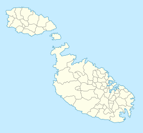
Ras ir-Raħeb, known also as Ras il-Knejjes is a scenic limestone promontory in north western Malta, close to the hamlet of Baħrija. The headland is located in the administrative area of the council of Rabat. Ras ir-Raħeb lies in the north western corner of the Rabat-Dingli-Mdina plateau, just off Fomm ir-Riħ Bay. It rises to 45 metres above sea level. The peak allows views of the west coast of the island, as far as the cliffs of Ta' Ċenċ in Gozo. A wide variety of vegetation grows on the headland, including large populations of esparto grass on the clay slopes in the area. The headland also serves as a navigational marker.
The headland incorporates the ruins of a megalithic temple, as well as Punic-Roman remains. Scholars have been arguing about the function of these remains for centuries. Interpretations differ from a domestic villa to a small religious shrine, as well as a major temple dedicated to Heracles. The headland is also a popular diving site, which also includes a cave. The Ras ir-Raħeb coastline forms part of the Rdum Majjiesa to Ras ir-Raħeb marine protected area, the first marine area to be protected in Malta, in 2005.
The two Maltese toponyms, Hermit's Headland (Maltese: Ras ir-Raħeb) and Churches' Headland (Maltese: Ras il-Knejjes) may indicate that the site had an established religious significance in the late Middle Ages. The coast between Rdum Majjiesa and Ras ir-Raħeb was earmarked and proposed for protection, in a number of local environmental heritage management documents, including The Structure Plan for the Maltese Islands and the UNEP/MAP Coastal Area Management Programme (CAMP) Report for Malta.
...
Wikipedia

