Randolph, Minnesota
| Randolph, Minnesota | |
|---|---|
| City | |
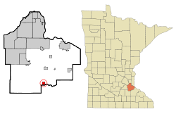
 Location of the city of Randolph within Dakota County, Minnesota |
|
| Coordinates: 44°31′30″N 93°1′10″W / 44.52500°N 93.01944°W | |
| Country | United States |
| State | Minnesota |
| County | Dakota |
| Area | |
| • Total | 1.03 sq mi (2.67 km2) |
| • Land | 0.96 sq mi (2.49 km2) |
| • Water | 0.07 sq mi (0.18 km2) |
| Elevation | 879 ft (268 m) |
| Population (2010) | |
| • Total | 436 |
| • Estimate (2012) | 444 |
| • Density | 454.2/sq mi (175.4/km2) |
| Time zone | Central (CST) (UTC-6) |
| • Summer (DST) | CDT (UTC-5) |
| ZIP code | 55065 |
| Area code(s) | 507, 651 |
| FIPS code | 27-53098 |
| GNIS feature ID | 0649818 |
Randolph is a city in Dakota County, Minnesota, United States. The population was 436 at the 2010 census.
A post office called Randolph has been in operation since 1886. The city took its name from Randolph Township.
According to the United States Census Bureau, the city has a total area of 1.03 square miles (2.67 km2), of which 0.96 square miles (2.49 km2) is land and 0.07 square miles (0.18 km2) is water. State Highway 56 serves as a main route in the community. U.S. Highway 52 and State Highway 19 are near Randolph.
Randolph is located in the southern part of Dakota County. The boundary line between Dakota, Goodhue, and Rice counties is near Randolph.
Lake Byllesby and the Cannon River are both nearby. Randolph is located entirely within Randolph Township geographically but is a separate entity.
As of the census of 2010, there were 436 people, 168 households, and 118 families residing in the city. The population density was 454.2 inhabitants per square mile (175.4/km2). There were 177 housing units at an average density of 184.4 per square mile (71.2/km2). The racial makeup of the city was 98.4% White, 0.2% Asian, and 1.4% from two or more races. Hispanic or Latino of any race were 1.8% of the population.
...
Wikipedia
