Randall County
| Randall County, Texas | ||
|---|---|---|

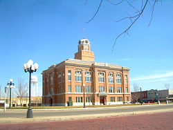
The Randall County Courthouse in 2011
|
||
|
||
 Location in the U.S. state of Texas |
||
 Texas's location in the U.S. |
||
| Founded | 1889 | |
| Named for | Horace Randal | |
| Seat | Canyon | |
| Largest city | Amarillo | |
| Area | ||
| • Total | 922 sq mi (2,388 km2) | |
| • Land | 912 sq mi (2,362 km2) | |
| • Water | 11 sq mi (28 km2), 1.2% | |
| Population | ||
| • (2010) | 120,725 | |
| • Density | 132/sq mi (51/km²) | |
| Congressional district | 13th | |
| Time zone | Central: UTC-6/-5 | |
| Website | www |
|
Randall County is a county located in the U.S. state of Texas. As of the 2010 census, its population was 120,725. Its county seat is Canyon. The county was created in 1876 and later organized in 1889. It is named for Horace Randal, a Confederate brigadier general killed at the Battle of Jenkins Ferry. The reason the county name differs from his is because the bill creating the county misspelled Randal's name.
Randall County is part of the Amarillo, Texas, Metropolitan Statistical Area.
At one time, the large JA Ranch, founded by Charles Goodnight and John George Adair, which reached into six counties, held acreage in Randall County.
According to the U.S. Census Bureau, the county has a total area of 922 square miles (2,390 km2), of which 912 square miles (2,360 km2) is land and 11 square miles (28 km2) (1.2%) is covered by water.
Palo Duro Canyon, the second-largest canyon in the United States, is located in Randall County.
As of the census of 2000, 104,312 people, 41,240 households, and 28,785 families resided in the county. The population density was 114 people per square mile (44/km²). The 43,261 housing units averaged 47 per square mile (18/km²). The racial makeup of the county was 90.44% White, 1.50% Black or African American, 0.65% Native American, 1.03% Asian, 0.03% Pacific Islander, 4.71% from other races, and 1.64% from two or more races. About 10.3% of the population were Hispanic or Latino of any race.
...
Wikipedia

