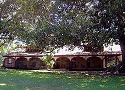
Rancho Los Alamitos
|
Rancho Los Alamitos
|
|

The exterior house at Rancho Los Alamitos, circa July 2008.
|
|
| Location | 6400 Bixby Hill Rd., Long Beach, California |
|---|---|
| Coordinates | 33°46′36″N 118°6′25″W / 33.77667°N 118.10694°WCoordinates: 33°46′36″N 118°6′25″W / 33.77667°N 118.10694°W |
| Area | 7.4 acres (3.0 ha) |
| Built | between 1800 and 1834 |
| Architect | unknown |
| Architectural style | Spanish Colonial |
| NRHP Reference # | 81000153 |
| Added to NRHP | July 7, 1981 |
Rancho Los Alamitos takes its name from a Mexican land grant in southwestern Los Angeles County and northwestern Orange County, California. Los Alamitos means the Little Cottonwoods or Poplars in Spanish, after the native Fremont Cottonwood (Populus fremontii) trees there.
Rancho Los Alamitos originally included much of present-day eastern Long Beach and all of the Orange County cities/communities of Los Alamitos and Rossmoor and most of Seal Beach, Cypress, Stanton and Garden Grove in Southern California. It is also sometimes referred to as Bixby Ranch, after its last private owners. The early 19th century adobe ranch house, still stands today, housing a museum which presents the history of the area.
The history of the 85,000-acre (340 km2) Rancho Los Alamitos is almost a microcosm for the history of expansion throughout Southern California, from the Native Americana cultures to contemporary times. The area was first the location of the major circa 500 C.E. - 1780s Tongva—Gabrieliño sacred ceremonial and trading village of Povuu'nga, now an archeological site. After Spanish occupation the ownership was to change and the boundaries would shrink many times. Situated in the floodplain between the mouths of the ever-shifting Los Angeles, San Gabriel and Santa Ana Rivers, the coastal plain terrain of the rancho is virtually flat rich soil, and was subject to frequent flooding. The rancho building itself is located near Puvunga springs alongside on one of the few small hills, Alamitos Mesa, in the area.
...
Wikipedia


