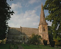
Ramsden, Oxfordshire
| Ramsden | |
|---|---|
 St James' parish church |
|
| Ramsden shown within Oxfordshire | |
| Population | 342 (2011 Census) |
| OS grid reference | SP3515 |
| Civil parish |
|
| District | |
| Shire county | |
| Region | |
| Country | England |
| Sovereign state | United Kingdom |
| Post town | Chipping Norton |
| Postcode district | OX7 |
| Dialling code | 01993 |
| Police | Thames Valley |
| Fire | Oxfordshire |
| Ambulance | South Central |
| EU Parliament | South East England |
| UK Parliament | |
| Website | Ramsden in the Oxfordshire Cotswolds |
Ramsden is a village and civil parish about 3 1⁄2 miles (5.6 km) north of Witney in West Oxfordshire. The 2011 Census recorded the parish's population as 342.
In the western part of the parish, about 1 mile (1.6 km) west of the village and just off the road to Leafield, is a bowl barrow. It is about 22 metres (72 ft) wide and 0.5 metres (1 ft 8 in) high, and is surrounded by the remains of a ditch that would originally have been about 2 metres (6 ft 7 in) wide. The barrow is either Bronze Age or late Neolithic, and therefore dating from between 2400 and 1500 BC. It is a Scheduled Ancient Monument.
There is a 440-yard (400 m) length of Grim's Ditch on a north-south axis just west of Ramsden village. It may be Iron Age or post-Roman.
The course of Akeman Street Roman Road linking Cirencester with London passes through the parish, bisecting the village. It is now part of the Wychwood Way long distance path.
The site of a Roman villa or bath house has been found at Brize Lodge Farm, west of the village and just west of the bowl barrow. Artefacts recovered include a bronze figurine of a dove-like bird.
Ramsden Methodist chapel in the High Street was built in 1804. It is now a private house.
...
Wikipedia

