Leafield
| Leafield | |
|---|---|
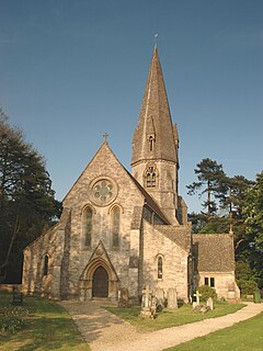
 St Michael's parish church |
|
| Leafield shown within Oxfordshire | |
| Population | 945 (2011 Census) |
| OS grid reference | SP3115 |
| Civil parish |
|
| District | |
| Shire county | |
| Region | |
| Country | England |
| Sovereign state | United Kingdom |
| Post town | Witney |
| Postcode district | OX29 |
| Dialling code | 01993 |
| Police | Thames Valley |
| Fire | Oxfordshire |
| Ambulance | South Central |
| EU Parliament | South East England |
| UK Parliament | |
| Website | Leafield Village |
Leafield is a village and civil parish about 4 miles (6.4 km) northwest of Witney in West Oxfordshire. The parish includes the hamlet of Langley, 1 mile (1.6 km) west of Leafield village. The 2011 Census recorded the parish's population as 945.
The village is 635 feet (194 m) above sea level in the Cotswold Hills. It was the highest point in Oxfordshire until the 1974 county boundary changes enlarged the county.
There are a number of tumuli in the parish. Atop the hill just to the north of the village is Leafield Barrow, locally called Barry's Hill Tump.
The parish is within the former limits of the Wychwood forest. The area of forest south of Langley was cleared in 1857–58, leaving straight, regular field boundaries typical of the 18th and 19th century enclosures.
The village has the remains of a medieval preaching cross. The steps and lower part of its base are old. A new Gothic Revival shaft and top were added in 1873 in thanksgiving for the village escaping a smallpox epidemic.
Leafield was a dependent chapelry of the ecclesiastical parish of Shipton-under-Wychwood until the 19th century. Leafield's Church of England parish church of Saint Michael and All Angels was designed by Sir George Gilbert Scott, built in 1859 and consecrated in 1860. The bell tower was completed in 1874 and has a ring of six bells, all cast that year by John Taylor & Co of Loughborough. St. Michael's is now a member of the Forest Edge Benefice.
...
Wikipedia

