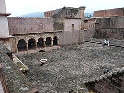
Ramnagar, Udhampur
|
Ramnagar, Udhampur (Jammu) Ramnagar Naggar |
|
|---|---|
| Municipality Town | |

Icon of Ramnagar(Ram Singh Palace)
|
|
| Nickname(s): Naggar | |
| Location in Jammu and Kashmir, India | |
| Coordinates: 32°49′N 75°19′E / 32.82°N 75.32°ECoordinates: 32°49′N 75°19′E / 32.82°N 75.32°E | |
| Country |
|
| State | Jammu and Kashmir |
| District | Udhampur |
| Founded by | King Ram Singh |
| Named for | King Ram Singh |
| Government | |
| • Type | Indian gov |
| • Body | Jammu And Kashmir Government |
| • MLA | Ranbir Singh Pathania |
| Elevation | 601 m (1,972 ft) |
| Population (2001) | |
| • Total | 6,776 |
| Languages | |
| • Official | Hindi, Urdu and English |
| Time zone | IST (UTC+5:30) |
| PIN | 182119-24 |
| Telephone code | 01990 |
| Vehicle registration | jk 14 |
| Website | udhampur.nic.in |
Ramnagar is both a town and a notified area committee in Udhampur District in the Indian state of Jammu and Kashmir.
Ramanagar is a historical small town Situated in Udhampur District of J & K. Ramnagar is named after its last ruler, King Ram Singh of Ramanagar. He was a brave dogra king. The King' Palace is also in the town. It has been taken over by ASI for maintenance and preservation. Inside the palace there is one sheesh mahal or a kind of hall where we can still see the painting of different types some are of the queens. Ramnagar is mostly a hilly Seoz glaciers and samna banj hills are some of the very high altitude areas. Main attractions of Ramnagar are:
M/S GUPTA TENT HOUSE RAMNAGAR
Ramnagar sits on the Mansa Devi Nallah, a tributary of the River Tawi that flows through Jammu. It is 27 km off the Udampur-Dhar-Pathankot road. The 19th-century palace, Rani's Samadhi (mausoleum) and the impressive fortress are all under the care of the Archaeological Survey of India.
Ramnagar town was once the capital of the Bandralta State whose last king, Bhupendra Dev, was ousted in 1821 by Sikh forces and retired into obscurity near Ambala in today's Haryana state. Ramnagar's 19th-century palace complex consisting of three sections was built by Raja, Suchet Singh (ruled 1822 to 1844), brother of Jammu Raja Gulab Singh - a prominent Dogra warrior in the campaign to oust Bhupendra Dev. and by Ram Singh, son of Rajah Ranbir Singh
Ramnagar is located at 32°49′N 75°19′E / 32.82°N 75.32°E. It has an average elevation of 828 metres (2716 feet). Ramnagar is hilly and roughly 90% forested aleit with scrubby, secondary growth in many parts. Local attractions include the pilgrimage sites of Chountra Mata to each of which a "AKHAND JYOTI" is carried on the eve of Navratra (which is scheduled twice a year). This yatra (pilgrimage) is carried with great fervour and dedication towards Maa Durga And Maa Kali. These pilgrimages are traditionally performed on foot though a motorable road is now under construction to Chontra Mata.http://keylr.com/sheesh-mahal-palace-ramnagar/
...
Wikipedia


