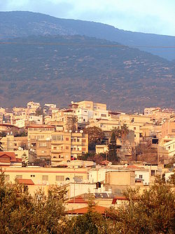
Rameh
Rameh
|
|
|---|---|
| Hebrew transcription(s) | |
| • ISO 259 | Ráma |
| • Also spelled | Rame (official) al-Rama (unofficial) |
 |
|
| Coordinates: 32°56′21.3″N 35°22′1.61″E / 32.939250°N 35.3671139°ECoordinates: 32°56′21.3″N 35°22′1.61″E / 32.939250°N 35.3671139°E | |
| Grid position | 184/260 PAL |
| District | Northern |
| Government | |
| • Type | Local council (from 2005) |
| Area | |
| • Total | 6,118 dunams (6.118 km2 or 2.362 sq mi) |
| Population (2015) | |
| • Total | 7,433 |
| Name meaning | "Lofty" or "Elevated" |
Rameh (Arabic: الرامة; Hebrew: רָמָה; also ar-Rame or ar-Rama) is an Arab town in the Northern District of Israel. Located east of Nahef and Karmiel, in 2015 it had a population of 7,433.
Edward Robinson identifies Rameh with the ancient Ramah of Asher (Joshua 19:29), citing its location and ancient sarcophagi discovered on a hill outside the village as evidence.
The village is situated on an ancient site, atop a hill at the edge of Beit HaKerem Valley. To the east are remains of Roman baths, dating to the 2nd to 4th century, and oil presses from the same period. South and southeast are remains of buildings foundations, including an Aramaic inscription on a lintel, which indicate a 3rd to 4th century synagogue. To the northeast of the Roman bath are the remains of a large basilica. This was excavated in 1972, and very large column bases were found, together with polychrome mosaics representing fauna and flora.
Many remains of pottery vessels dated to the Late Roman period (fourth–fifth centuries CE) have also been found, together with building remains from the Byzantine period. Rameh was a major town during the rule of the Crusaders.
...
Wikipedia

