Ramat Hasharon
Ramat HaSharon
|
|||
|---|---|---|---|
| Hebrew transcription(s) | |||
| • ISO 259 | Ramat ha Šaron | ||

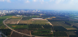
Aerial view of Ramat HaSharon
|
|||
|
|||
| Coordinates: 32°09′N 34°50′E / 32.150°N 34.833°ECoordinates: 32°09′N 34°50′E / 32.150°N 34.833°E | |||
| Country | Israel | ||
| District | Tel Aviv | ||
| Founded | 1923 | ||
| Government | |||
| • Type | City | ||
| • Mayor | Avi Gruber | ||
| Area | |||
| • Total | 16,792 dunams (16.792 km2 or 6.483 sq mi) | ||
| Population (2015) | |||
| • Total | 44,427 | ||
| Name meaning | Sharon Height | ||
| Website | ramat-hasharon.muni.il | ||
Ramat HaSharon (Hebrew: רָמַת הַשָּׁרוֹן, lit. Height of the Sharon) is a city located on Israel's central coastal strip in the south of the Sharon region, bordering Tel Aviv to the south, Hod HaSharon to the east and Herzliya and Kibbutz Glil Yam to the north. It is part of the Tel Aviv District, within Gush Dan metropolitan area. In 2015 it had a population of 44,427.
Ramat HaSharon, originally Ir Shalom, was a moshava established in 1923 (Hebrew: עִיר שָׁלוֹם, lit. City of Peace) by olim from Poland. It was built on 2,000 dunams (2 square kilometres (0.77 sq mi)) of land purchased for 5 Egyptian pounds per dunam. In the 1931 census, the village had a population of 312.
In 1932, the community was renamed Kfar Ramat HaSharon (Heights of Sharon Village). By 1950, the population was up to 900. Rapid population growth in the 1960s and 70s led to construction of many new roadways, schools and parks. Several distinct neighborhood evolved in the 1970s, including Morasha on the southern edge, one with many military and air force personnel in the eastern edge, and many successful professionals moved into the developing city. Ramat HaSharon became a highly desirable place to live in the 1980s as a very safe place, containing many gardens and wide boulevards, and attracting many upper middle class suburban families.
Ramat HaSharon was granted city status in 2002.
...
Wikipedia


