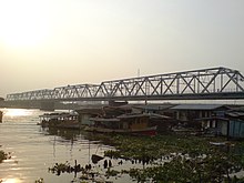
Rama VI Bridge
| Rama VI Bridge | |
|---|---|

View from east bank
|
|
| Coordinates | 13°48′47″N 100°30′57″E / 13.813108°N 100.515826°ECoordinates: 13°48′47″N 100°30′57″E / 13.813108°N 100.515826°E |
| Carries | 2 Railway tracks, pedestrians |
| Crosses | Chao Phraya river |
| Locale | Bangkok, Thailand |
| Official name | Saphan Phra Ram Hok |
| Characteristics | |
| Design | 5-span through-truss |
| Total length | 441.44 metres |
| Longest span | 120.00 metres |
| History | |
| Construction begin | 1922 |
| Construction end | December 1926 |
| Opened | 1 January 1927 |
Rama VI Bridge (Thai: สะพานพระราม 6) is a railway bridge over the Chao Phraya River in Bangkok, in Thailand, connecting the districts Bang Sue and Bang Phlat. It was the first bridge to cross the Chao Phraya River. Construction started in December 1922 during the reign of Rama VI to link the Northern and Eastern rail lines with the southern rail lines. It was officially opened on 1 January 1927. The bridge was severely damaged during World War II, was repaired 1950-1953 and officially reopened on 12 December 1953.
The bridge is located 13.149 km from Hua Lamphong (Bangkok) railway station, between Bang Son and Bang Bamru stations. The bridge has 5 spans, all of through-truss design: 77.26, 83.46, 120.00, 83.46 m and 77.26 m respectively, for a total length of 441.44 metres. It is thus the longest railway bridge in Thailand, almost 110 metres longer than its nearest rival, the 132.00 metre River Kwai bridge near Kanchanaburi.
Bangkok Tourist Division (2004). "RAMA VI BRIDGE @ bangkoktourist.com". Archived from the original on 2007-12-10.
...
Wikipedia
